Global Data Catalog - Pitney Bowes
Global Data Catalog - Pitney Bowes
Global Data Catalog - Pitney Bowes
You also want an ePaper? Increase the reach of your titles
YUMPU automatically turns print PDFs into web optimized ePapers that Google loves.
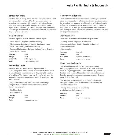
Asia Pacific: India & Indonesia<br />
StreetPro ® India<br />
StreetPro India is <strong>Pitney</strong> <strong>Bowes</strong> Business Insight’s premier street<br />
network database for India. StreetPro can be resourced for<br />
geocoding and mapping with <strong>Pitney</strong> <strong>Bowes</strong> Business Insight<br />
software at various geographic resolutions, including capital city<br />
region, or national coverage. Routing and logistics solutions can<br />
also leverage StreetPro with its comprehensive street network over<br />
major population centers.<br />
More Information<br />
StreetPro is packed with an extensive array of layers:<br />
• Roads (Detailed, Highways and main roads)<br />
• Administrative Boundaries (District, Subdistrict, State)<br />
• Postal Code Points (boundaries in Delhi)<br />
• Contextual Information (Rail and Stations, Rivers, Township<br />
points, feature points)<br />
Coverage:<br />
India<br />
Vintage: 2008<br />
Unit of Sale: India; Capital City<br />
Scale: 1:15,000 to 1:250,000<br />
Postcodes India<br />
Postcodes India is a boundary data representation of<br />
all the 6-digit post codes in India. It has been created to assist<br />
in assigning post codes according to the geographic location<br />
of an address. The product is an excellent reference layer for<br />
users wishing to geocode/locate corporate data to a post code<br />
boundary level.<br />
The postcode boundaries are currently defined through<br />
amalgamation of administrative boundaries in India.<br />
These boundaries are:<br />
• Ward boundaries<br />
• State boundaries<br />
Coverage:<br />
India<br />
Vintage: 2008<br />
Scale: 1:15,000 to 1:250,000<br />
StreetPro ® Indonesia<br />
StreetPro Indonesia is <strong>Pitney</strong> <strong>Bowes</strong> Business Insight’s premier<br />
street network database for Indonesia. StreetPro can be resourced<br />
for geocoding and mapping with <strong>Pitney</strong> <strong>Bowes</strong> Business Insight<br />
software at various geographic resolutions, including capital city<br />
region or national coverage. Routing and logistics solutions can<br />
also leverage StreetPro with its comprehensive street network over<br />
major population centers.<br />
More Information<br />
StreetPro is packed with an extensive array of layers:<br />
• Roads (Detailed, Highways, Main Roads)<br />
• Boundaries (Village, District, Sub-district, Province)<br />
• Postal Boundaries<br />
• Feature points<br />
Coverage:<br />
Indonesia<br />
Vintage: 2008<br />
Unit of Sale: Indonesia; Capital City<br />
Scale: 1:15,000 to 1:250,000<br />
Postcodes Indonesia<br />
Postcodes Indonesia is a boundary data representation<br />
of all 5-digit postcodes in Indonesia. It has been created to<br />
assist in assigning postcodes according to the geographic<br />
location of an address. The product is an excellent reference<br />
layer for users wishing to geocode/locate corporate data to a<br />
postcode boundary level.<br />
The postcode boundaries are currently defined through<br />
amalgamation of administrative boundaries in Indonesia.<br />
These boundaries are:<br />
• Village boundaries (called Kelurahan)<br />
• Sub-district (called Kecamatan)<br />
Coverage:<br />
Indonesia<br />
Vintage: 2008<br />
Scale: 1:15,000 to 1:250,000<br />
FOR MORE INFORMATION ON PITNEY BOWES BUSINESS INSIGHT DATA PRODUCTS,<br />
VISIT US ONLINE AT WWW.PBINSIGHT.COM/PRODUCTS/DATA/<br />
9


