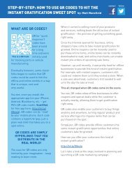
Global Data Catalog - Pitney Bowes
Global Data Catalog - Pitney Bowes
Global Data Catalog - Pitney Bowes

You also want an ePaper? Increase the reach of your titles
YUMPU automatically turns print PDFs into web optimized ePapers that Google loves.
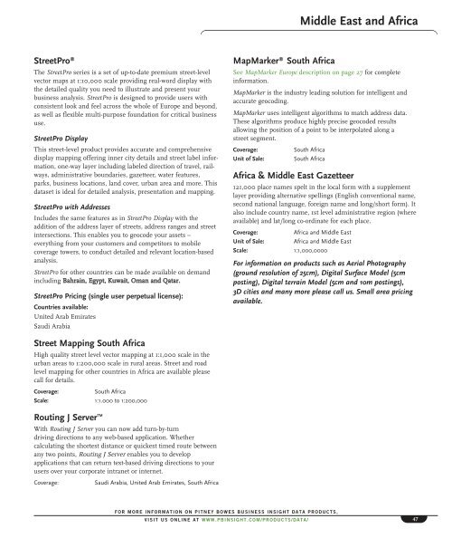
Middle East and Africa<br />
StreetPro ®<br />
The StreetPro series is a set of up-to-date premium street-level<br />
vector maps at 1:10,000 scale providing real-word display with<br />
the detailed quality you need to illustrate and present your<br />
business analysis. StreetPro is designed to provide users with<br />
consistent look and feel across the whole of Europe and beyond,<br />
as well as flexible multi-purpose foundation for critical business<br />
use.<br />
StreetPro Display<br />
This street-level product provides accurate and comprehensive<br />
display mapping offering inner city details and street label information,<br />
one-way layer including labeled direction of travel, railways,<br />
administrative boundaries, gazetteer, water features,<br />
parks, business locations, land cover, urban area and more. This<br />
dataset is ideal for detailed analysis, presentation and mapping.<br />
StreetPro with Addresses<br />
Includes the same features as in StreetPro Display with the<br />
addition of the address layer of streets, address ranges and street<br />
intersections. This enables you to geocode your assets –<br />
everything from your customers and competitors to mobile<br />
coverage towers, to conduct detailed and relevant location-based<br />
analysis.<br />
StreetPro for other countries can be made available on demand<br />
including Bahrain, Egypt, Kuwait, Oman and Qatar.<br />
StreetPro Pricing (single user perpetual license):<br />
Countries available:<br />
United Arab Emirates<br />
Saudi Arabia<br />
MapMarker ® South Africa<br />
See MapMarker Europe description on page 27 for complete<br />
information.<br />
MapMarker is the industry leading solution for intelligent and<br />
accurate geocoding.<br />
MapMarker uses intelligent algorithms to match address data.<br />
These algorithms produce highly precise geocoded results<br />
allowing the position of a point to be interpolated along a<br />
street segment.<br />
Coverage:<br />
Unit of Sale:<br />
South Africa<br />
South Africa<br />
Africa & Middle East Gazetteer<br />
121,000 place names spelt in the local form with a supplement<br />
layer providing alternative spellings (English conventional name,<br />
second national language, foreign name and long/short form). It<br />
also include country name, 1st level administrative region (where<br />
available) and lat/long co-ordinate for each place.<br />
Coverage:<br />
Africa and Middle East<br />
Unit of Sale: Africa and Middle East<br />
Scale: 1:1,000,0000<br />
For information on products such as Aerial Photography<br />
(ground resolution of 25cm), Digital Surface Model (5cm<br />
posting), Digital terrain Model (5cm and 10m postings),<br />
3D cities and many more please call us. Small area pricing<br />
available.<br />
Street Mapping South Africa<br />
High quality street level vector mapping at 1:1,000 scale in the<br />
urban areas to 1:200,000 scale in rural areas. Street and road<br />
level mapping for other countries in Africa are available please<br />
call for details.<br />
Coverage:<br />
South Africa<br />
Scale: 1:1.000 to 1:200,000<br />
Routing J Server TM<br />
With Routing J Server you can now add turn-by-turn<br />
driving directions to any web-based application. Whether<br />
calculating the shortest distance or quickest timed route between<br />
any two points, Routing J Server enables you to develop<br />
applications that can return text-based driving directions to your<br />
users over your corporate intranet or internet.<br />
Coverage:<br />
Saudi Arabia, United Arab Emirates, South Africa<br />
FOR MORE INFORMATION ON PITNEY BOWES BUSINESS INSIGHT DATA PRODUCTS,<br />
VISIT US ONLINE AT WWW.PBINSIGHT.COM/PRODUCTS/DATA/<br />
47