Northside - City of Riverside
Northside - City of Riverside
Northside - City of Riverside

Create successful ePaper yourself
Turn your PDF publications into a flip-book with our unique Google optimized e-Paper software.
the little store, recall the haven the Fairmount Grocery, where the tennis courts are<br />
located now, <strong>of</strong>fered many days while playing at the park (Mermilliod & Klure<br />
2005b). Historic amenities in Fairmount Park that have been altered and improved<br />
over the decades and features that have been lost, including the <strong>Riverside</strong> Municipal<br />
Auto Camp (1914-1927), zoo and historic tennis courts (1933-1935), an aviary (circa<br />
1910-unknown), the plunge and a sulphur spring, and an amusement park with<br />
carousel (1947-1978) (Tang 2002:15-16). It was the C.W. Parker carousel (1912), which<br />
was designated in 1978 as <strong>City</strong> Landmark Object No. 27, that two <strong>Northside</strong>rs –<br />
Frances McArthur Wright and Bessie Brooks - remember best as each <strong>of</strong> them<br />
accepted marriage proposals there.<br />
RESIDENTIAL DEVELOPMENT<br />
The boom <strong>of</strong> the 1880s coincided with the completion <strong>of</strong> the California Southern and<br />
ATSF rail lines and the construction <strong>of</strong> the Gage Canal, which brought water to<br />
<strong>Riverside</strong>’s eastern plain and opened lands on the Eastside for large-scale<br />
subdivision. Thus, substantial residential tract development first expanded beyond<br />
the Mile Square to the east or separately in the Arlington community to the south,<br />
beyond the Government Tract. Some early residents <strong>of</strong> the <strong>Northside</strong> purchased<br />
land directly from the Southern California Colony Association and found the rural<br />
landscape <strong>of</strong> the <strong>Northside</strong> ideal for agricultural production and grove house<br />
construction, while others built homes designed for urban living. In <strong>Riverside</strong>, the<br />
boom time continued beyond the regional depression around 1887, with Victorian<br />
era homes constructed mainly in the Mile Square, but also scattered throughout the<br />
accessible areas <strong>of</strong> the <strong>City</strong>. While the national financial crisis <strong>of</strong> 1893 did slow<br />
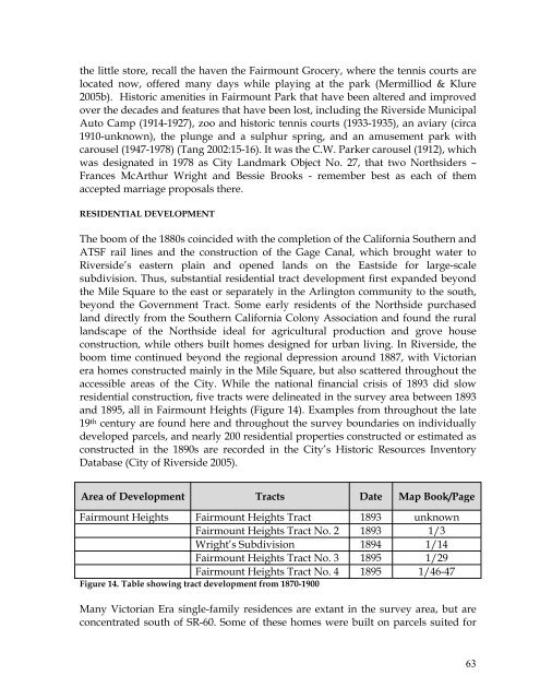
residential construction, five tracts were delineated in the survey area between 1893<br />
and 1895, all in Fairmount Heights (Figure 14). Examples from throughout the late<br />
19 th century are found here and throughout the survey boundaries on individually<br />
developed parcels, and nearly 200 residential properties constructed or estimated as<br />
constructed in the 1890s are recorded in the <strong>City</strong>’s Historic Resources Inventory<br />
Database (<strong>City</strong> <strong>of</strong> <strong>Riverside</strong> 2005).<br />
Area <strong>of</strong> Development Tracts Date Map Book/Page<br />
Fairmount Heights Fairmount Heights Tract 1893 unknown<br />
Fairmount Heights Tract No. 2 1893 1/3<br />
Wright’s Subdivision 1894 1/14<br />
Fairmount Heights Tract No. 3 1895 1/29<br />
Fairmount Heights Tract No. 4 1895 1/46-47<br />
Figure 14. Table showing tract development from 1870-1900<br />
Many Victorian Era single-family residences are extant in the survey area, but are<br />
concentrated south <strong>of</strong> SR-60. Some <strong>of</strong> these homes were built on parcels suited for<br />
63