- Page 1 and 2: A REPORT PREPARED FOR: KERI DAVIS-M
- Page 3 and 4: LIST OF FIGURES: Section 2: Introdu
- Page 5 and 6: Figure 6.7. Akaroa beach before WW
- Page 7 and 8: Figure 7.41. View of hillside veget
- Page 9 and 10: SECTION ONE: OVERVIEW Report Contex
- Page 11 and 12: It draws particular attention to wh
- Page 13 and 14: AKAROA: AN HISTORICAL OVERVIEW Sect
- Page 15 and 16: It had the appearance of remoteness
- Page 17 and 18: SECTION THREE: LANDSCAPE & HUMAN HI
- Page 19 and 20: Paka Ariki seems to have had a less
- Page 21 and 22: They appear also on occasion to hav
- Page 23 and 24: AKAROA: AN HISTORICAL OVERVIEW Sect
- Page 25 and 26: The settlers were given clear title
- Page 27 and 28: Commercial Hotel. (Green sold this
- Page 29 and 30: Figure 4.2. The cottage built in 18
- Page 31 and 32: Charlotte Godley, however, observed
- Page 33 and 34: THE NATURAL AND PLANTED LANDSCAPE P
- Page 35 and 36: own property in Takamatua and the n
- Page 37 and 38: By 1847 cropping and stock breeding
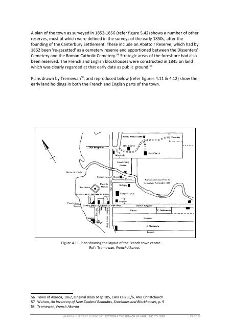
- Page 39: Figure 4.10. Father Sione's plan sh
- Page 43 and 44: EXTANT TOWN FABRIC & FEATURES DATIN
- Page 45 and 46: SECTION FIVE: THE COLONIAL TOWN 185
- Page 47 and 48: Akaroa’s transformation from vill
- Page 49 and 50: Although the proportion of Akaroa
- Page 51 and 52: The most important concentration of
- Page 53 and 54: The largest private home built in 1
- Page 55 and 56: He soon built his own store and coa
- Page 57 and 58: time after 1884 (probably in 1888)
- Page 59 and 60: Figure 5.17. In this view looking s
- Page 61 and 62: Industry Industry had less of an im
- Page 63 and 64: Public institutions As Akaroa grew
- Page 65 and 66: One of the organisations which met
- Page 67 and 68: The first Anglican church was built
- Page 69 and 70: distinctively Akaroa style of archi
- Page 71 and 72: The Akaroa Mail greeted the formati
- Page 73 and 74: Figure 5.28. For a time in the late
- Page 75 and 76: THE COLONIAL LANDSCAPE The disappea
- Page 77 and 78: By 1900 the forest was virtually go
- Page 79 and 80: Figure 5.32. Walnut Avenue was the
- Page 81 and 82: Figure 5.34. Charles Haylock's prop
- Page 83 and 84: The resort garden and the seaside h
- Page 85 and 86: The re-invigoration of the town's e
- Page 87 and 88: public gardens in the colony” 122
- Page 89 and 90: Britomart or Green's Point Monument
- Page 91 and 92:
Names on the landscape in 1900 The
- Page 93 and 94:
c SNAPSHOT OF AKAROA IN 1900 The 19
- Page 95 and 96:
Public buildings and structures •
- Page 97 and 98:
AKAROA: AN HISTORICAL OVERVIEW Sect
- Page 99 and 100:
During and just after World War II,
- Page 101 and 102:
with the previous half century. Two
- Page 103 and 104:
The unveiling of the monument on Gr
- Page 105 and 106:
Figure 6.5. James Bruce established
- Page 107 and 108:
grounds, was dedicated to the wives
- Page 109 and 110:
Building a dairy factory in Akaroa
- Page 111 and 112:
Community Life Between 1900 and 195
- Page 113 and 114:
The building of the Post Office was
- Page 115 and 116:
through Little River and over Hillt
- Page 117 and 118:
Power from the Lake Coleridge power
- Page 119 and 120:
area without the fear of currents a
- Page 121 and 122:
Land reclaimed on the northern beac
- Page 123 and 124:
Akaroa cemetery: “the most inviti
- Page 125 and 126:
Figure 6.23 The central memorial fe
- Page 127 and 128:
Centennial celebrations In preparat
- Page 129 and 130:
In addition to built landscape elem
- Page 131 and 132:
Coronation Oaks were planted on L'A
- Page 133 and 134:
Figure 6.34. Aylmers Valley Road in
- Page 135 and 136:
Figure 6.36. The Narbey family home
- Page 137 and 138:
c SNAPSHOT OF AKAROA IN 1950 Descri
- Page 139 and 140:
Public buildings and structures •
- Page 141 and 142:
SECTION SEVEN: CHANGE AND GROWTH 19
- Page 143 and 144:
When the Akaroa County first drew u
- Page 145 and 146:
The Metropole and Bruce fires left
- Page 147 and 148:
offered from the 1970s and more rec
- Page 149 and 150:
By the late 20 th century, a town w
- Page 151 and 152:
ensure as far as possible that the
- Page 153 and 154:
Figure 7.7. In this aerial view tak
- Page 155 and 156:
This expectation was fulfilled. In
- Page 157 and 158:
On Rue Balguerie, subdivision in 19
- Page 159 and 160:
But the spread of houses onto those
- Page 161 and 162:
Figure 7.16. Some architects who de
- Page 163 and 164:
Farrell stated her case against the
- Page 165 and 166:
Figure 7.19. Behind the recent and
- Page 167 and 168:
Figure 7.22. The Haylock House on A
- Page 169 and 170:
In 1970 a local complained to the w
- Page 171 and 172:
Figure 7.25. The new gymnasium on t
- Page 173 and 174:
Figure 7.26. General view of Akaroa
- Page 175 and 176:
palms, sumach, chestnuts and walnut
- Page 177 and 178:
Commemorative fabric and historic t
- Page 179 and 180:
The changing face of the Domain Dur
- Page 181 and 182:
Cemetery reserves: “nothing but c
- Page 183 and 184:
widened in part to better accommoda
- Page 185 and 186:
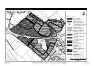
Figure 7.38. 1972 map of Akaroa . P
- Page 187 and 188:
c SNAPSHOT OF AKAROA TODAY The seco
- Page 189 and 190:
EXTANT TOWN FABRIC DATING FROM 1950
- Page 191 and 192:
AKAROA: AN HISTORICAL OVERVIEW Sect
- Page 193 and 194:
Come to Akaroa Canterbury’s Premi
- Page 195 and 196:
Vangioni. L. J. (1967) Old Maori pl
- Page 197 and 198:
Akaroa Mail, 7 September 2001 Akaro
- Page 199 and 200:
AKAROA: AN HISTORICAL OVERVIEW Sect
- Page 201 and 202:
Appendix 2. Although Akaroa's popul
- Page 203 and 204:
Appendix 4. Typically, subdivisions
- Page 205 and 206:
Appendix 6. In 1946, the block of l
- Page 207 and 208:
Appendix 8. In 1953, the extensive
- Page 209 and 210:
Appendix 10. In 1962, one of the fi
- Page 211 and 212:
Appendix 12. After the major subdiv
- Page 213 and 214:
Appendix 14. On the south side of A
- Page 215 and 216:
Appendix 16. The most recent large
- Page 217 and 218:
Appendix 18. Nearly 20 years passed
- Page 219 and 220:
Appendix 20. In 1971, the block of
- Page 221 and 222:
Appendix 22. A 1981 subdivision saw
- Page 223 and 224:
Appendix 24. The Settlers Hill subd
- Page 225 and 226:
Appendix 26. The houses on Percy St
- Page 227 and 228:
Appendix 28. As development extende
- Page 229:
Appendix 30. As development crept u