Hidden Valleys of Southwestern Wisconsin
Hidden Valleys of Southwestern Wisconsin
Hidden Valleys of Southwestern Wisconsin

You also want an ePaper? Increase the reach of your titles
YUMPU automatically turns print PDFs into web optimized ePapers that Google loves.
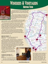
Lakes, Trails and Streams ~ Driving Tour<br />
From spectacular sunrises over Castle Rock Lake to calm<br />
canoeing on the crooked river <strong>of</strong> The Kickapoo, we invite you<br />
to enjoy serene summers, vibrant fall colors, and the winter<br />
playground <strong>of</strong> the lakes, trails, and streams region <strong>of</strong> southwestern<br />
<strong>Wisconsin</strong>’s <strong>Hidden</strong> <strong>Valleys</strong>. Activities for the entire family include<br />
swimming, boating, fishing, hiking, camping, canoeing, picnicking,<br />
hunting, cross-country skiing, and snowmobiling are here for all to<br />
enjoy!<br />
We begin the adventure at the Lyndon Station exit <strong>of</strong><br />
I-90/94 in Juneau County, which was once an Irish settlement.<br />
Hwy HH north is the route to pursue, which encompasses the<br />
juncture <strong>of</strong> Lemonweir River and <strong>Wisconsin</strong> River. There are several<br />
locations to plunge right into fun.<br />
Turning left onto<br />
Hwy 82, we now head<br />
west toward Mauston.<br />
Along this major route,<br />
no matter what season<br />
it may be, there is<br />
horseback riding or<br />
sleigh rides along the<br />
Lemonweir River at<br />
Red Ridge Ranch and<br />
breakfast on the trail at<br />
Woodside Ranch.<br />
Getting closer to<br />
Mauston on Hwy 82 west<br />
you will find Packarama,<br />
a flea market delight.<br />
After exploring all the<br />
shops and sales available<br />
there, a wide variety<br />
<strong>of</strong> restaurants eagerly<br />
await your arrival in<br />
Mauston. Refueling your body and your car, continue on Hwy<br />
82 west and turn right at the corner <strong>of</strong> The Bank <strong>of</strong> Mauston, just<br />
one block before the intersection <strong>of</strong> Hwy 82 & 58. Several blocks<br />
down, is a four way stop sign, turn right. This leaves Mauston on<br />
Hwy G, which has several sharp curvy turns with plenty <strong>of</strong> scenic<br />
countryside between them.<br />
At the next four way stop sign, Hwy G continues to the right<br />
followed by another sharp curve. The intersection after that has<br />
Hwy HH and Hwy G coming together at Castle Rock Hideaway.<br />
Going straight leads you to fourth largest inland lake in <strong>Wisconsin</strong><br />
<strong>of</strong> Castle Rock Lake. Castle Rock Park hosts fireworks, food, and<br />
family fun as it celebrates Waterfest the 1st Saturday in August.<br />
After enjoying the park, turn right onto Hwy G heading west.<br />
There are campgrounds, boat landings & restaurants along the lake.<br />
Turn right onto 17 th street and continue<br />
on as the road curves to the left and<br />
becomes 37 th street, which will take<br />
you to Hwy 58. At Hwy 58 turn<br />
right to head north and then<br />
right again at the next junction,<br />
Hwy G, to Buckhorn State Park.<br />
Crossing the Buckhorn Bridge<br />
provides safe passage toward the state park. Stay and enjoy the park<br />
area awhile before turning right out <strong>of</strong> Buckhorn. Then follow Hwy<br />
G winding its way several miles towards Hwy 21 in Necedah. If<br />
turning left on Hwy. 21, go approximately 4 miles to the entrance<br />
<strong>of</strong> the Necedah National Wildlife Refuge. This is the home <strong>of</strong> the<br />
Whooping Cranes, Karner Blue Butterfly, Blanding turtles, and<br />
Trumpeter swans. If at Hwy. 21 you turn right, you will cross over<br />
the <strong>Wisconsin</strong> River to go to the wayside for picnicking,<br />
boat launching, fishing, or just a rest stop.<br />
Petenwell Rock can be seen looking across the river.<br />
Leaving the wayside, cross over the <strong>Wisconsin</strong> River again and<br />
take the first right turn (19th street), then right again on 18th.<br />
This takes you to Petenwell Dam on Petenwell Lake. Power<br />
dams on the <strong>Wisconsin</strong> River created both Castle Rock and<br />
Petenwell Lakes, the second largest inland lake in <strong>Wisconsin</strong>.<br />
Retrace the drive back to Hwy 21, turning right. Follow Hwy 21<br />
west to Hwy G north. This time your destination is Wilderness<br />
County Park on Petenwell Lake for more camping, fishing,<br />
swimming, and boating. Upon leaving the park, take Hwy. G<br />
(left) back to<br />
Hwy 21 west (right) to go into Necedah.<br />
Take time to explore the antique shops and the flea market<br />
before heading north on Hwy. 80. If your travel is on the 3rd<br />
Saturday in September, stop in at the Whooping Crane Festival<br />
before continuing on to the Sprague, Finley, Mather<br />
area. Turn left at the Wilderness Inn Bar & Grill to go thru<br />
part <strong>of</strong> the Sprague Mather Flowage in the Necedah National<br />
Wildlife Refuge. The Refuge has various educational events<br />
including the National Crane Count each April.<br />
When you get to Hwy H, turn left to get to the Eagles<br />
Nest Flowage for more water sports and fun. Hwy H south<br />
is a countryside drive into Camp Douglas, the start <strong>of</strong><br />
the Omaha Bike Trail at Target Bluff German Haus. Leave<br />
Camp Douglas headed west on Hwy 12 & 16 to Mill Bluff<br />
State Park. The village <strong>of</strong> Oakdale is next with the Antique<br />
Mall. Continuing on brings you into Tomah past the famous<br />
Burnstad’s European Café. Great place to take a break and<br />
check out some Amish goods. Cross over Superior Avenue<br />
following Hwy 16 towards Tomah Recreation Park. Make a<br />
right turn onto Butts Avenue to get to Winnebago Park. The<br />
City <strong>of</strong> Tomah’s Recreation Trail winds through Winnebago<br />
Park, Veteran’s Park, and Butts Park. For more information,<br />
contact the Tomah Area Chamber at 1-800-948-6624.<br />
Backtrack on Butts Avenue to Hwy 16 to continue this<br />
adventure headed west toward Sparta. In Sparta, walking or<br />
bicycling the 32-mile Elroy-Sparta National Bike Trail is a<br />
great adventure for the entire family to enjoy the scenery along<br />
La Crosse River or Beaver Creek. Leaving Sparta via its<br />
downtown may bring shopping adventures to a new level with<br />
the unique stores and historical buildings. Definitely a must see<br />
before traveling on Hwy 27 south to Cashton, “the heart <strong>of</strong><br />
Amish Country.” Cashton has panoramic views <strong>of</strong> the hills and<br />
valleys throughout the Amish community.<br />
84 www.hiddenvalleys.com <strong>Hidden</strong> <strong>Valleys</strong>