Full-text - Norsk entomologisk forening
Full-text - Norsk entomologisk forening
Full-text - Norsk entomologisk forening

Create successful ePaper yourself
Turn your PDF publications into a flip-book with our unique Google optimized e-Paper software.
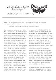
Norwegian stone/lies II 201<br />
areas (Table I) where geographical, geological'<br />
climatical (Figs. 2 and 3) and botanical<br />
aspects could be studied separately.<br />
The location of the study areas is shown in<br />
Fig. 4. The arrows indicate more detailed<br />
special investigations along the most probable<br />
invasion routes to western Norway.<br />
The areas chosen were: 1. The area north<br />
of Boknafjord, Rogaland and the southernmost<br />
areas of Hordaland. 2. The area around<br />
Oslofjord. 3. North 0sterdal and the surrounding<br />
areas. 4. The 0vre Heimdal area.<br />
5. The area around Kautokeino. 6. The Alta<br />
area. 7. South Varanger including Pasvik<br />
and Korpfjell.<br />
To categorize the main vegetation zones,<br />
the system of Sjors (1963, 1967) was used.<br />
According to this system, area 1 ranges from<br />
the North Atlantic Pine-Birch Woodland<br />
and heath region through the Sub-Alpine<br />
Birch Woodland belt to the Alpine belts.<br />
Area 2 is situated in the Boreo-nemoral zone,<br />
area 3 in the Sub-Arctic and Boreo-montane<br />
sub-zone and area 4 in the upper part of the<br />
Sub-Alpine Birch Woodland and the Alpine<br />
belts. Area 5 (Kautokeino) also lies in the<br />
Sub-Alpine and Alpine belts. In area 6 (Alta)<br />
there are pine woods in the lowest parts,<br />
while most of the area lies in the Sub-Alpine<br />
Birch Woodland belt and the Alpine belts.<br />
In area 7, Pasvik is situated in the Sub-Arctic<br />
and Boreo-montane sub-zone while the Korpfjell<br />
area lies in the Sub-Alpine and Alpine<br />
belts.<br />
The major part of the study was undertaken<br />
in area 1 where there are very marked<br />
climatic and botanic gradients, and considerable<br />
difference in the altitude within a relatively<br />
small area, making it possible to investigate<br />
an extremely large range at nearly<br />
the same time.<br />
SOUTHERN NORWAY<br />
Area 1. North Rogaland and South<br />
Hordaland<br />
After a preliminary investigation of the<br />
plecopteran fauna of 64 localities, covering<br />
Fig. 4. The investigated areas (shaded) and the<br />
presumed immigration routes towards the west<br />
(arrows).<br />
Fig. 5. The investigated parts of area 1. A =<br />
coastal areas, B = central areas, C = inner fjords.<br />
the whole of Rogaland and the southern<br />
parts of Hordaland, the area between Boknafjorden<br />
and Bemlafjorden-Akrafjorden was<br />
chosen as the most representative for this<br />
investigation. There are clear climatic and<br />
vegetation gradients which make the area<br />
suitable for examining the gradient of the<br />
decrease in species which seems to occur<br />
towards the coasts of Norway, especially the<br />
western seaboard.<br />
Area description<br />
The area is shown in Fig. 5, and studies<br />
were carried out in 41 localities.<br />
Pre-Eocambrian rock complexes occur in<br />
the lower sections of the valleys, phyllites<br />
higher up the valley sides, and acidic igneous<br />
rocks on the top. Drift materal consisting of<br />
stones, gravel and sand occurs in the river<br />
valleys of the inner area. In the lower areas<br />
along the fjords, marine clay deposits occur<br />
which become larger towards the coast (Holtedal<br />
1960).<br />
The coastal climate dominates over large