

Fort Erie Creeks Watershed Plan - Niagara Peninsula Conservation ...
Fort Erie Creeks Watershed Plan - Niagara Peninsula Conservation ...
Fort Erie Creeks Watershed Plan - Niagara Peninsula Conservation ...

Create successful ePaper yourself
Turn your PDF publications into a flip-book with our unique Google optimized e-Paper software.
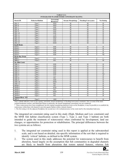
TABLE 5.3.1:<br />
INTEGRATED WATERCOURSE CONSTRAINT RATING<br />
Terrestrial<br />
Reach ID<br />
Fisheries/Habitat<br />
Resources 1 Stream Morphology Flooding/Conveyance Net Rating<br />
FRC-5 Type 1 M/H M M H<br />
FRC-6 Type 1 M/H M M H<br />
FRC-7 Type 1 H/H M H H<br />
FRC-8 Type 1 M/H M M H<br />
FRC-9 Type 1 H/H M M H<br />
FRC-10 Type 1 H/H M M H<br />
FRC-11 Type 1 L/H M M H<br />
FRC-12 Type 1 M/H M M H<br />
FRC-13 Type 1 H/H M H H<br />
FRC-14 Type 1 H/H M M H<br />
FRC-15 Type 1 M/M M M H<br />
Kraft Drain<br />
KFD-1 Type 3 H/H M H H<br />
KFD-2 Type 3 H/H M H H<br />
KFD-3 Type 3 H/H M H H<br />
KFD-4 Type 3 H/H M H H<br />
KFD-5 Type 3 H/H L H *H<br />
Bertie Bay Drain<br />
BBD-1 Type 2 L/L M L<br />
BBD-2 Type 2 H/L M M<br />
Six Mile Creek<br />
SMC-1 Type 1 H/H M H H<br />
SMC-2 Type 1 H/H M H H<br />
SMC-3 Type 1 H/H M H H<br />
SMC-4 Type 1 H/H M H H<br />
SMC-5 Type 1 H/H M H H<br />
SMC-6 Type 1 H/H M H *H<br />
SMC-7 Type 1 L/L M H H<br />
SMC-8 Type 1 H/L M H H<br />
SMC-9 Type 1 H/H M H H<br />
SMC-10 Type 1 M/M M H H<br />
SMC-11 Type 1 M/L M H H<br />
MND-1 Type 1 H/L M H H<br />
MND-2 Type 1 H/M M H H<br />
MND-3 Type 1 H/L M H H<br />
MND-4 Type 1 M/M M H H<br />
MND-5 Type 1 H/L M H H<br />
MND-6 Type 1 H/L M H H<br />
<strong>Niagara</strong> River #19<br />
DR1,2 Type 3 H/H H<br />
Note: a blank indicates a lack of any aquatic, terrestrial, stream morphology or flooding/conveyance constraint. Also, in some of the more<br />
isolated headwater reaches, and Municipal Drains in particular, the stream morphologic assessment was not conducted.<br />
* These watercourses have been straightened, but the original meandering planform exists on the floodplain, it may be possible to re-establish the<br />
watercourse within these old channels to provide aquatic habitat within a natural channel.<br />
1. The first rating is for the adjacent floodplain; the second one is for wetland presence in the creek itself or the immediate bank area.<br />
The integrated net constraint rating used in this study (High, Medium and Low constraint) and<br />
the MNR fish habitat classification system (Type 1, Type 2, and Type 3 habitat) are both<br />
intended to guide the treatment of watercourses when confronted by development, land use<br />
changes, or opportunities for protection or rehabilitation. The principal differences between the<br />
two systems are as follows:<br />
1. The integrated net constraint rating used in this report is applied at the subwatershed<br />
scale, and is not based on detailed, site-specific information of the sort that is required to<br />
identify ‘critical’ habitats, as defined in the MNR system.<br />
2. The system used in this study addresses the potential for watercourses to benefit from<br />
alteration, based largely on the assumption that fish communities in degraded channels<br />
are likely to benefit from alterations that restore natural features, whereas fish<br />
March 2008 159 <strong>Fort</strong> <strong>Erie</strong> <strong>Creeks</strong> <strong>Watershed</strong> <strong>Plan</strong><br />
General Report (105116)


