

Fort Erie Creeks Watershed Plan - Niagara Peninsula Conservation ...
Fort Erie Creeks Watershed Plan - Niagara Peninsula Conservation ...
Fort Erie Creeks Watershed Plan - Niagara Peninsula Conservation ...

You also want an ePaper? Increase the reach of your titles
YUMPU automatically turns print PDFs into web optimized ePapers that Google loves.
% wetland<br />
% original wetland**<br />
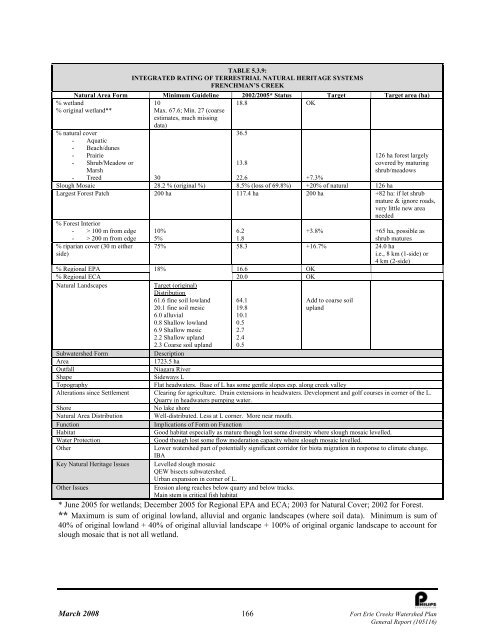
TABLE 5.3.9:<br />
INTEGRATED RATING OF TERRESTRIAL NATURAL HERITAGE SYSTEMS<br />
FRENCHMAN’S CREEK<br />
Natural Area Form Minimum Guideline 2002/2005* Status Target Target area (ha)<br />
10<br />
18.8 OK<br />
Max. 67.6; Min. 27 (coarse<br />
estimates, much missing<br />
data)<br />
% natural cover<br />
- Aquatic<br />
- Beach/dunes<br />
- Prairie<br />
- Shrub/Meadow or<br />
Marsh<br />
- Treed 30<br />
36.5<br />
13.8<br />
126 ha forest largely<br />
covered by maturing<br />
shrub/meadows<br />
22.6 +7.3%<br />
Slough Mosaic 28.2 % (original %) 8.5% (loss of 69.8%) +20% of natural 126 ha<br />
Largest Forest Patch 200 ha 117.4 ha 200 ha +82 ha: if let shrub<br />
mature & ignore roads,<br />
very little new area<br />
needed<br />
% Forest Interior<br />
- > 100 m from edge 10%<br />
6.2<br />
+3.8% +65 ha, possible as<br />
- > 200 m from edge 5%<br />
1.8<br />
shrub matures<br />
% riparian cover (30 m either<br />
side)<br />
75% 58.3 +16.7% 24.0 ha<br />
i.e., 8 km (1-side) or<br />
4 km (2-side)<br />
% Regional EPA 18%<br />
16.6 OK<br />
% Regional ECA<br />
20.0 OK<br />
Natural Landscapes<br />
Target (original)<br />
Distribution<br />
61.6 fine soil lowland<br />
20.1 fine soil mesic<br />
64.1<br />
19.8<br />
Add to coarse soil<br />
upland<br />
6.0 alluvial<br />
0.8 Shallow lowland<br />
6.9 Shallow mesic<br />
2.2 Shallow upland<br />
2.3 Coarse soil upland<br />
10.1<br />
0.5<br />
2.7<br />
2.4<br />
0.5<br />
Subwatershed Form<br />
Description<br />
Area<br />
1723.5 ha<br />
Outfall<br />
<strong>Niagara</strong> River<br />
Shape<br />
Sideways L<br />
Topography<br />
Flat headwaters. Base of L has some gentle slopes esp. along creek valley<br />
Alterations since Settlement Clearing for agriculture. Drain extensions in headwaters. Development and golf courses in corner of the L.<br />
Quarry in headwaters pumping water.<br />
Shore<br />
No lake shore<br />
Natural Area Distribution Well-distributed. Less at L corner. More near mouth.<br />
Function<br />
Implications of Form on Function<br />
Habitat<br />
Good habitat especially as mature though lost some diversity where slough mosaic levelled.<br />
Water Protection<br />
Good though lost some flow moderation capacity where slough mosaic levelled.<br />
Other<br />
Lower watershed part of potentially significant corridor for biota migration in response to climate change.<br />
IBA<br />
Key Natural Heritage Issues Levelled slough mosaic<br />
QEW bisects subwatershed.<br />
Urban expansion in corner of L.<br />
Other Issues<br />
Erosion along reaches below quarry and below tracks.<br />
Main stem is critical fish habitat<br />
* June 2005 for wetlands; December 2005 for Regional EPA and ECA; 2003 for Natural Cover; 2002 for Forest.<br />
** Maximum is sum of original lowland, alluvial and organic landscapes (where soil data). Minimum is sum of<br />
40% of original lowland + 40% of original alluvial landscape + 100% of original organic landscape to account for<br />
slough mosaic that is not all wetland.<br />
March 2008 166 <strong>Fort</strong> <strong>Erie</strong> <strong>Creeks</strong> <strong>Watershed</strong> <strong>Plan</strong><br />
General Report (105116)


