

Fort Erie Creeks Watershed Plan - Niagara Peninsula Conservation ...
Fort Erie Creeks Watershed Plan - Niagara Peninsula Conservation ...
Fort Erie Creeks Watershed Plan - Niagara Peninsula Conservation ...

Create successful ePaper yourself
Turn your PDF publications into a flip-book with our unique Google optimized e-Paper software.
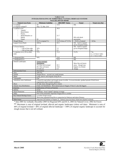
TABLE 5.3.8:<br />
INTEGRATED RATING OF TERRESTRIAL NATURAL HERITAGE SYSTEMS<br />
NIAGARA RIVER SHORE<br />
Natural Area Form Minimum Guideline 2002/2005* Status Target Target area (ha)<br />
% wetland<br />
10<br />
15.8 OK<br />
% original wetland**<br />
Max. 72; Min. 28.8<br />
% natural cover<br />
49.0<br />
- Aquatic<br />
- Beach/dunes<br />
- Prairie<br />
- Shrub/Meadow or<br />
21.7<br />
Marsh<br />
OK with shrub<br />
- Treed 30<br />
27.4<br />
succession<br />
Slough Mosaic 54.1% (original %) 14.5% (loss of 73.3%) + 39.6% of natural + 68 ha<br />
Largest Forest Patch 200 ha 85.5 OK – hard to expand<br />
given elongated shape<br />
% Forest Interior<br />
- > 100 m from edge<br />
- > 200 m from edge<br />
% riparian cover (30 m either<br />
side)<br />
10%<br />
5%<br />
3.1<br />
0.1<br />
OK – hard to expand<br />
given elongated shape<br />
75% 51.6 23.4% 7 ha<br />
i.e., 2.2 km (1 side)<br />
or 1.1 km (2-side)<br />
18%<br />
37.8 OK<br />
% Regional EPA 12.0 OK<br />
% Regional ECA<br />
Natural Landscapes<br />
Target (original)<br />
Distribution<br />
71.6 fine soil lowland 85.1<br />
28.1 fine soil mesic<br />
14.6<br />
0.4 alluvial<br />
0.3<br />
Subwatershed Form<br />
Area<br />
Outfall<br />
Shape<br />
Topography<br />
Alterations since Settlement<br />
Shore<br />
Natural Area Distribution<br />
Function<br />
Habitat<br />
Water Protection<br />
Other<br />
Key Natural Heritage Issues<br />
Other Issues<br />
More fine soil mesic<br />
areas – though may<br />
happen via climate<br />
change<br />
Description<br />
349.4 ha<br />
<strong>Niagara</strong> River – several very small streams<br />
Long, narrow and irregular along River.<br />
Flat<br />
Cleared for agriculture and slough mosaic levelled. In recent decades, gradual spread of both forest<br />
regeneration and riverside residences.<br />
No lake shore (though long River shore)<br />
Fairly well distributed. Most natural area in <strong>Niagara</strong> 19 but it’s also the biggest.<br />
Implications of Form on Function<br />
Good.<br />
Moderate. Good “inland” riparian coverage.<br />
Part of the potentially important <strong>Niagara</strong> River corridor<br />
Levelled slough mosaic<br />
Most areas separated from River connection by Parkway and strip of houses.<br />
Important fish habitat in <strong>Niagara</strong> 19. Natural Areas Inventory found unevaluated wetlands.<br />
* June 2005 for wetlands; December 2005 for Regional EPA and ECA; 2003 for Natural Cover; 2002 for Forest.<br />
** Maximum is sum of original lowland, alluvial and organic landscapes (where soil data). Minimum is sum of<br />
40% of original lowland + 40% of original alluvial landscape + 100% of original organic landscape to account for<br />
slough mosaic that is not all wetland.<br />
March 2008 165 <strong>Fort</strong> <strong>Erie</strong> <strong>Creeks</strong> <strong>Watershed</strong> <strong>Plan</strong><br />
General Report (105116)


