Fort Erie Creeks Watershed Plan - Niagara Peninsula Conservation ...
Fort Erie Creeks Watershed Plan - Niagara Peninsula Conservation ...
Fort Erie Creeks Watershed Plan - Niagara Peninsula Conservation ...
You also want an ePaper? Increase the reach of your titles
YUMPU automatically turns print PDFs into web optimized ePapers that Google loves.
Two hydrograph algorithms have been used in the watershed model: CALIB NASHYD has been<br />
used for the rural subcatchments and CALIB STANDHYD has been used for the urban<br />
subcatchments. Any subcatchment with an impervious coverage of less than 10 % has been<br />
considered to be rural, and a subcatchment with an impervious coverage of greater than 10 % has<br />
been assumed to be urban. The existing land use model parameters are listed in Table 2.2.4.<br />
The hydrologic routing, (i.e. routing of flows through creeks and reaches), has been modeled<br />
using the ROUTE CHANNEL algorithm. This algorithm requires a typical cross-section, which<br />
represents the channel and floodplain of each reach. A total of 17 typical sections have been<br />
determined based on the digital topographic mapping and applied over similar reaches<br />
throughout the study area.<br />
Subwatershed Delineation and Parameterization<br />
Previous studies that defined the watershed boundaries and municipal drains have been used as<br />
the starting point for the delineation of the subwatersheds (e.g. the Marshall Macklin Monaghan<br />
NPCA <strong>Watershed</strong> Study in 1986, which used the MNR 1:10,000 OBM for base mapping).<br />
All watershed boundaries provided by the Town were developed by Drainage Engineers and<br />
adopted by Town By-law, and therefore can only be changed using the process stipulated under<br />
the Drainage Act.<br />
For this study, the updated digital base mapping (Region, 2002), with 0.5 m contours, has been<br />
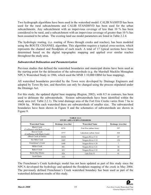
used to delineate the subwatersheds. Sixteen subwatersheds have been identified within the<br />
study area (ref. Table 2.2.1). The total drainage area of the <strong>Fort</strong> <strong>Erie</strong> <strong>Creeks</strong> varies from 7 ha to<br />
10656 ha. Within each watershed there are subwatersheds of smaller size. The subwatershed<br />
boundaries have been shown in Figure 8 and the schematics of subwatersheds are shown in<br />
Figure 9.<br />
TABLE 2.2.1:<br />
STUDY AREA SUBWATERSHEDS<br />
<strong>Watershed</strong> Name Drainage Area (ha) <strong>Watershed</strong> Name Drainage Area (ha)<br />
Black Creek<br />
(Confluence with Beaver Creek)<br />
6374 <strong>Fort</strong> <strong>Erie</strong> (urban Area) 397<br />
Beaver Creek<br />
(Confluence with Black Creek)<br />
3777 Lakeshore (urban Area) 364<br />
(Black Creek at Outlet) 10656 <strong>Niagara</strong> River # 16 87<br />
Six Mile Creek 1805 <strong>Niagara</strong> River # 19 159<br />
Frenchman’s Creek 1640 <strong>Niagara</strong> River # 20 7<br />
Miller Creek 901 <strong>Niagara</strong> River # 21 36<br />
Baker Creek 431 <strong>Niagara</strong> River # 22 60<br />
Bertie Bay Drains 826 Lake <strong>Erie</strong> #1 41<br />
Kraft Drain 555<br />
The Frenchman’s Creek hydrologic model has not been updated as part of this study since the<br />
NPCA developed the hydrology and updated the floodplain mapping of the creek in May 2004.<br />
The previously defined Frenchman’s Creek watershed boundary has been used as part of the<br />
watershed delineation results of this study.<br />
March 2008 15 <strong>Fort</strong> <strong>Erie</strong> <strong>Creeks</strong> <strong>Watershed</strong> <strong>Plan</strong><br />
General Report (105116)


