

Fort Erie Creeks Watershed Plan - Niagara Peninsula Conservation ...
Fort Erie Creeks Watershed Plan - Niagara Peninsula Conservation ...
Fort Erie Creeks Watershed Plan - Niagara Peninsula Conservation ...

Create successful ePaper yourself
Turn your PDF publications into a flip-book with our unique Google optimized e-Paper software.
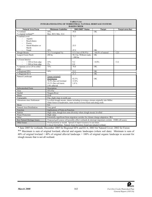
TABLE 5.3.6:<br />
INTEGRATED RATING OF TERRESTRIAL NATURAL HERITAGE SYSTEMS<br />
BAKER CREEK<br />
Natural Area Form Minimum Guideline 2002/2005* Status Target Target area (ha)<br />
% wetland<br />
10%<br />
39.8 OK -<br />
% original wetland**<br />
Max. 80.9; Min. 32.4<br />
% natural cover<br />
72.7<br />
- Aquatic<br />
- Beach/dunes<br />
- Prairie<br />
- Shrub/Meadow or<br />
Marsh<br />
25.5<br />
- Treed 30%<br />
47.2 OK -<br />
Slough Mosaic 75.1 % (original %) 8.3 ( loss of 88.9%) +66.8% of natural +221<br />
Largest Forest Patch 200 ha 98.3 ha. Without roads, OK<br />
>200 ha<br />
% Forest Interior<br />
- > 100 m from edge 10%<br />
9.2<br />
+0.8% +3.6<br />
- > 200 m from edge 5%<br />
0.8<br />
% riparian cover (30 m either 75% 78.8 OK<br />
side)<br />
% Regional EPA 18%<br />
33.3 OK<br />
% Regional ECA<br />
21.3 OK<br />
Natural Landscape<br />
Target (original)<br />
Distribution<br />
82.5%<br />
OK<br />
78.9% fine soil lowland<br />
19.1% fine soil mesic<br />
2.0% alluvial<br />
15.8%<br />
1.8 %<br />
Subwatershed Form<br />
Description<br />
Area<br />
455.0 ha<br />
Outfall<br />
<strong>Niagara</strong> River<br />
Shape<br />
Oval<br />
Topography<br />
Flat, slight slope in north east<br />
Alterations since Settlement Levelled slough mosaic, drains including reversing a stream originally into Miller.<br />
Older forest in headwaters, more recent in lower basin and along creek<br />
Shore<br />
NA<br />
Natural Area Distribution Very good<br />
Function<br />
Implications of Form on Function<br />
Habitat<br />
High value, though lost some diversity where slough mosaic levelled<br />
Water Protection<br />
High value<br />
Other<br />
Potentially significant biota migration corridor for climate change adaptation. IBA<br />
Key Natural Heritage Issues Proposed golf course will possibly affect wetlands & interrupt important corridor. OMB will assess<br />
Other Issues<br />
Flood potential at mouth. Spread of imperviousness in east drain.<br />
Critical fish habitat. Natural Areas Inventory found unevaluated wetland.<br />
* June 2005 for wetlands; December 2005 for Regional EPA and ECA; 2003 for Natural Cover; 2002 for Forest.<br />
** Maximum is sum of original lowland, alluvial and organic landscapes (where soil data). Minimum is sum of<br />
40% of original lowland + 40% of original alluvial landscape + 100% of original organic landscape to account for<br />
slough mosaic that is not all wetland.<br />
March 2008 163 <strong>Fort</strong> <strong>Erie</strong> <strong>Creeks</strong> <strong>Watershed</strong> <strong>Plan</strong><br />
General Report (105116)


