- Page 1 and 2: FORT ERIE CREEKS - WATERSHED PLAN M
- Page 3 and 4: TABLE OF CONTENTS Section Page No.
- Page 5 and 6: TABLE OF CONTENTS Section Page No.
- Page 7 and 8: TABLE OF CONTENTS GENERAL REPORT AP
- Page 9 and 10: 1.3 Administration This study has b
- Page 11 and 12: 2. WATERSHED AREA CHARACTERIZATION
- Page 13 and 14: sediment and topographic breaks. In
- Page 15 and 16: The make up of the Halton Till and
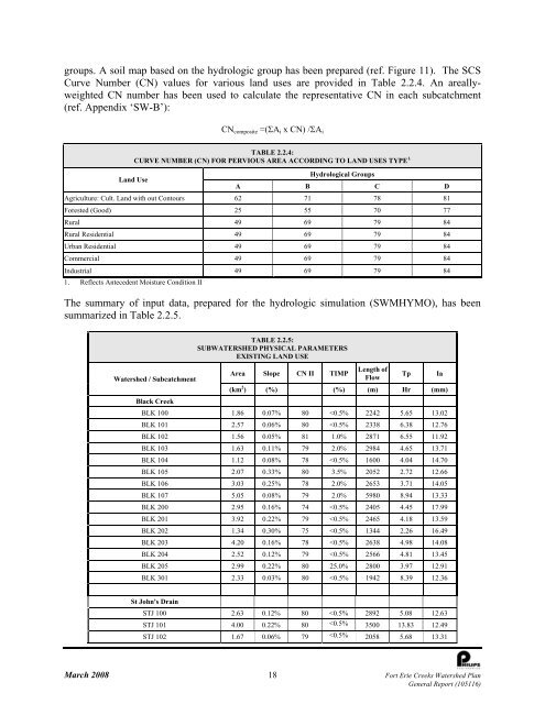
- Page 17 and 18: Any modest level of additional grou
- Page 19 and 20: NPCA Groundwater Study did delineat
- Page 21 and 22: oundary under the Drainage Act. The
- Page 23: The majority of the urban areas of
- Page 27 and 28: Baker Creek TABLE 2.2.5: Con’t SU
- Page 29 and 30: Creek and Baker Creek have higher u
- Page 31 and 32: Location Node TABLE 2.2.8: FREQUENC
- Page 33 and 34: RiverCAD TM has been used to develo
- Page 35 and 36: Culvert ID Watersheds TABLE 2.3.1:
- Page 37 and 38: Culvert ID Watersheds TABLE 2.3.1:
- Page 39 and 40: agricultural purposes prior to 1955
- Page 41 and 42: fields. Due to the scale and qualit
- Page 43 and 44: were constructed between 1978 and 2
- Page 45 and 46: level survey of the site extending
- Page 47 and 48: Field Investigations 2.5.2 Work Act
- Page 49 and 50: Marginal Habitat: those fisheries h
- Page 51 and 52: natural channel, except for a 1.3 k
- Page 53 and 54: The fish community in the lower por
- Page 55 and 56: TABLE 2.5.2: RECENT MINISTRY OF NAT
- Page 57 and 58: Characterization of the natural her
- Page 59 and 60: TABLE 2.6.1: TERRESTRIAL NATURAL HE
- Page 61 and 62: The soil units included in each lan
- Page 63 and 64: • Percent of interior forest: >10
- Page 65 and 66: Subwatershed TABLE 2.6.4: COVER TYP
- Page 67 and 68: The main percentage shift from “o
- Page 69 and 70: and 1976. These changes removed a f
- Page 71 and 72: The regulated species are listed in
- Page 73 and 74: TABLE 2.6.9: PROVINCIALLY & NATIONA
- Page 75 and 76:
illed Gull (spring migration only),
- Page 77 and 78:
ated Locally Significant, a high pr
- Page 79 and 80:
subwatersheds, many of the forest p
- Page 81 and 82:
proportions; many of the mesic site
- Page 83 and 84:
TABLE 2.7.4: NPCA BENTHIC INVERTEBR
- Page 85 and 86:
Site ID Date Alkalinity Aluminum Am
- Page 87 and 88:
Site ID Date Alkalinity Aluminum Am
- Page 89 and 90:
Site ID Date Alkalinity Aluminum Am
- Page 91 and 92:
Site ID Date Alkalinity Aluminum Am
- Page 93 and 94:
A review of the NPCA water quality
- Page 95 and 96:
TABLE 2.7.1 SUMMARY OF ANNUAL CONTA
- Page 97 and 98:
The Lake Erie Shoreline Management
- Page 99 and 100:
ackshore. In most area, the structu
- Page 101 and 102:
3. SUMMARY OF POLICIES, OBJECTIVES
- Page 103 and 104:
TABLE 3.1.1: SUMMARY OF ACTS AND GU
- Page 105 and 106:
Level of Government Regional Level
- Page 107 and 108:
The Clean Water Protection Act 2006
- Page 109 and 110:
3.1.3 Stream Morphology It is NPCA
- Page 111 and 112:
Type 3: areas with low productive c
- Page 113 and 114:
The principles advanced in the docu
- Page 115 and 116:
TABLE 3.1.3: SUMMARY OF POLICIES, S
- Page 117 and 118:
e) To ensure the preservation of La
- Page 119 and 120:
• Prevent installation of barrier
- Page 121 and 122:
Targets: • Priority to long-term
- Page 123 and 124:
The purpose of the hydrologic model
- Page 125 and 126:
Watershed / Subcatchment TABLE 4.1.
- Page 127 and 128:
TABLE 4.1.4: 100 YEAR PEAK FLOW COM
- Page 129 and 130:
Watershed Damage Location NPCA Floo
- Page 131 and 132:
not necessarily reflect absolute ch
- Page 133 and 134:
potentially increase the erosion in
- Page 135 and 136:
TABLE 4.22: SUMMARY OF ANNUAL CONTA
- Page 137 and 138:
Several Special Policy Areas includ
- Page 139 and 140:
TABLE 4.3.2: TERRESTRIAL NATURAL HE
- Page 141 and 142:
TABLE 4.3.2: TERRESTRIAL NATURAL HE
- Page 143 and 144:
Subwatershed TABLE 4.3.4: MODERATE
- Page 145 and 146:
Similar to other Fort Erie Creeks,
- Page 147 and 148:
the channel as part of the Niagara
- Page 149 and 150:
In order to summarize the findings
- Page 151 and 152:
lakes, seepage areas, recharge/disc
- Page 153 and 154:
Regional Municipality of Niagara ca
- Page 155 and 156:
• Maintain existing shading veget
- Page 157 and 158:
d) Restoration of the slough mosaic
- Page 159 and 160:
‣ Enhancement for subwatersheds w
- Page 161 and 162:
and value of the stream system. The
- Page 163 and 164:
If there is no registered floodplai
- Page 165 and 166:
TABLE 5.3.1: INTEGRATED WATERCOURSE
- Page 167 and 168:
communities in natural channels wit
- Page 169 and 170:
TABLE 5.3.5: INTEGRATED RATING OF T
- Page 171 and 172:
TABLE 5.3.7: INTEGRATED RATING OF T
- Page 173 and 174:
% wetland % original wetland** TABL
- Page 175 and 176:
TABLE 5.3.11: INTEGRATED RATING OF
- Page 177 and 178:
TABLE 5.3.13: INTEGRATED RATING OF
- Page 179 and 180:
5.4 Local Subwatershed Opportunitie
- Page 181 and 182:
ase conditions have almost eliminat
- Page 183 and 184:
c) Confirm and/or refine wetland bo
- Page 185 and 186:
• Kraft Drain north of Dominion R
- Page 187 and 188:
REACH NAME TABLE 5.4.3: PLANNING LE
- Page 189 and 190:
TABLE 5.4.6: SUMMARY OF LOCAL OPPOR
- Page 191 and 192:
TABLE 5.4.10: SUMMARY OF LOCAL OPPO
- Page 193 and 194:
TABLE 5.4.14: SUMMARY OF LOCAL OPPO
- Page 195 and 196:
Watercourses (erosion, fisheries) T
- Page 197 and 198:
In addition to the priority assigne
- Page 199 and 200:
TABLE 6.1.2: SUMMARY OF PRIORITIZED
- Page 201 and 202:
TABLE 6.1.6: SUMMARY OF PRIORITIZED
- Page 203 and 204:
TABLE 6.1.10: SUMMARY OF PRIORITIZE
- Page 205 and 206:
Cost Summary Each of the subwatersh
- Page 207 and 208:
In terms of water quality, the NPCA
- Page 209 and 210:
REFERENCES American Forests, 1999.
- Page 211 and 212:
Kingston, M.S. and E.W. Presant. 19
- Page 213 and 214:
GLOSSARY OF TERMS Alluvial Soil Sed
- Page 215 and 216:
Enhancement Strategies and actions
- Page 217 and 218:
Hydraulics Science pertaining to fl
- Page 219 and 220:
Off-line Stormwater infrastructure
- Page 221 and 222:
Settlement Area In the Fort Erie Cr
- Page 223 and 224:
ECA EIS EMC END EPA FEC FRC HEC-RAS