

Fort Erie Creeks Watershed Plan - Niagara Peninsula Conservation ...
Fort Erie Creeks Watershed Plan - Niagara Peninsula Conservation ...
Fort Erie Creeks Watershed Plan - Niagara Peninsula Conservation ...

You also want an ePaper? Increase the reach of your titles
YUMPU automatically turns print PDFs into web optimized ePapers that Google loves.
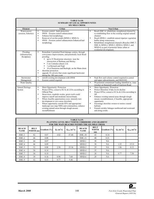
Watercourses<br />
(erosion, fisheries)<br />
TABLE 5.4.18:<br />
SUMMARY OF LOCAL OPPORTUNITES<br />
SIX MILE CREEK<br />
Element Urban Non-Urban<br />
• Erosion control– bank protection,<br />
• SWM – Erosion control enhancement<br />
• Enhance bed morphology<br />
• Removal of on-line ponds (MND-2, MND-5)<br />
• SWM – Erosion control enhancement Enhanced bed<br />
morphology<br />
Flooding<br />
(infrastructure,<br />
floodplain)<br />
Natural Heritage<br />
System<br />
• Remediate 4 potential flood damage centres, through<br />
conveyance improvements, and potentially local floodproofing:<br />
• up to 25 flood-prone structures near the<br />
intersection of Bethune and Shirley<br />
• 3 on Centralia (sheets 2,4)<br />
• 1 at Bernard and Nigh<br />
• 16 at Dominion and Burleigh, on the Mann drain<br />
• shoreline protection<br />
• upgrade 10 culverts that create significant backwater<br />
during the 100 year event<br />
• retrofit existing development with SWM<br />
• Erosion control required<br />
• Reach SMC-6: rehabilitate straightened channel by<br />
re-establishing flow in the existing original natural<br />
channel.<br />
• Reach MND-1: establish natural riparian vegetation<br />
buffer along watercourse.<br />
• Rehabilitate straightened channels (Reaches SMC-7,<br />
SMC-8, MND-2, MND-3, MND-4, MND-5, and<br />
MND-6) as part of potential future urban or<br />
residential development.<br />
Stormwater<br />
Management<br />
• Peak flow and volume control required in central<br />
and upper subcatchments, and MAN102.<br />
Water Quality • PS potential contaminant loading identified at. Auto<br />
wrecker on Stonemill south of Garrison Road<br />
• Main Opportunity: Protection<br />
• Main Opportunity: Protection<br />
• Protect EPAs; conserve ECAs & LSAs according to • Protect Shoreline if lake levels decline<br />
Official <strong>Plan</strong><br />
• Protect EPAs; conserve ECAs & LSAs according to<br />
• Street trees, roadside swales, green roofs could<br />
OP<br />
improve runoff and moderate microclimate.<br />
• Enhance existing natural areas through slough<br />
• Where feasible opportunities exist, intensify new<br />
mosaic reestablishment, if feasible, appropriate<br />
development to save areas elsewhere<br />
opportunity<br />
• Where opportunity outside EPA and appropriate • Encourage shoreline owners to restore coastal<br />
landscape (see map NH8) and communities, enhance habitats<br />
existing natural areas through slough mosaic<br />
• Extend corridor linkages northward and westward<br />
reestablishment<br />
and along creeks<br />
REACH<br />
NAME<br />
TABLE 5.4.19:<br />
PLANNING LEVEL BELT WIDTH CORRIDORS AND GRADIENT<br />
FOR THE MAIN REACHES WITHIN THE SIX MILE CREEK<br />
BELT<br />
WIDTH (m) Gradient (%) Q 2 (m 3 /s) Q 100 (m 3 /s)<br />
REACH<br />
NAME<br />
BELT<br />
WIDTH<br />
(m)<br />
Gradient (%) Q 2 (m 3 /s) Q 100 (m 3 /s)<br />
SMC-1 82 0.07 4.82 47.40 SMC-10 43 0.34<br />
SMC-2 46 0.08 SMC-11 40 0.51<br />
SMC-3 44 0.07 MND-1 38 NA<br />
SMC-4 46 0.09 MND-2 38 NA 1.52 15.31<br />
SMC-5 52 0.08 2.50 25.36 MND-3 29 NA 1.06 8.13<br />
SMC-6 30 0.14 MND-4 35 NA<br />
SMC-7 30 0.19 MND-5 28 NA 0.77 7.50<br />
SMC-8 30 0.16 0.96 7.68 MND-6 28 NA<br />
SMC-9 42 0.35 0.77 9.40<br />
March 2008 188 <strong>Fort</strong> <strong>Erie</strong> <strong>Creeks</strong> <strong>Watershed</strong> <strong>Plan</strong><br />
General Report (105116)


