Dam Synchronisation and Flood Releases - agriwaterpedia.info
Dam Synchronisation and Flood Releases - agriwaterpedia.info
Dam Synchronisation and Flood Releases - agriwaterpedia.info

Create successful ePaper yourself
Turn your PDF publications into a flip-book with our unique Google optimized e-Paper software.
DAM SYNCHRONISATION AND FLOOD RELEASES IN THE ZAMBEZI RIVER BASIN: ANNEX 4 OF FINAL REPORT<br />
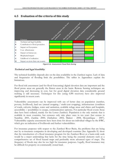
6.5 Evaluation of the criteria of this study<br />
A<br />
B<br />
C<br />
D<br />
E<br />
F<br />
G<br />
H<br />
Criterion<br />
Technical <strong>and</strong> legal feasibility<br />
Contribution to flood protection<br />
Impact on Ecosystems<br />
Cost effectiveness<br />
Impact on human use<br />
Biophysical impact<br />
Likelihood of realization<br />
Impact on more than one country<br />
<strong>Flood</strong> risk zoning for rules for new<br />
settlements<br />
<strong>Flood</strong> risk zoning for current l<strong>and</strong><br />
use <strong>and</strong> awareness raising<br />
Figure 6.6: Assessment <strong>Flood</strong> Risk Zoning<br />
<strong>Flood</strong> risk zoning for insurances<br />
<strong>Flood</strong> risk zoning for rescue <strong>and</strong><br />
warning<br />
Technical <strong>and</strong> legal feasibility<br />
The technical feasibility depends also on the data availability in the Zambezi region. Lack of data<br />
<strong>and</strong> frequencies of flooding limit the possibilities. The tables in Appendices explain the<br />
limitations.<br />
For flood risk assessment (<strong>and</strong> for flood forecasting) digital elevation data are important <strong>and</strong> the<br />
flood prone areas are generally the flattest areas in the basin. Remote Sensing techniques are<br />
improving <strong>and</strong> decreasing in cost, but for good digital elevation data considerable ground<br />
truthing is still necessary. Techniques for this (using GPS receivers) have also improved<br />
significantly in recent years.<br />
Vulnerability assessments can be improved with use of better data on population (number,<br />
poverty, livelihood), l<strong>and</strong> use (annual cropping / multi-year cropping), infrastructure (condition<br />
of roads, culverts, bridges, water <strong>and</strong> sanitation, available refuge areas <strong>and</strong> clinics <strong>and</strong> hospitals,<br />
accessibility / possibilities to escape, communication options). For particular flood events those<br />
data have been collated, mainly for the Lower Zambezi. Population is the only statistic that is<br />
available in most countries, but censuses only take place once in ten years (last census in<br />
Namibia- 2001, Zambia -2000, Zimbabwe -2002, Malawi - 2008, Mozambique - 2007).<br />
Vulnerability capacity assessments have been done for about ten individual villages by the IFRC,<br />
which give an indication of livelihoods <strong>and</strong> further vulnerabilities.<br />
For insurance purposes with respect to the Zambezi River Basin, the problems that are being<br />
met by re-insurance companies in developing <strong>and</strong> developed countries (See Appendix E) show<br />
that the introduction of a flood insurance program for the Zambezi River at a basin-wide scale<br />
would be a major undertaking that lacks for the time being the essential elements such as a<br />
comprehensive set of flood hazard maps <strong>and</strong> preferably more advanced types of maps. The<br />
frequency of floods may also be too high for insurance purposes. Legally, flood insurance may<br />
be difficult for property on communally owned l<strong>and</strong>.<br />
62