The Orange Avenue Corridor Specific Plan - City of Coronado
The Orange Avenue Corridor Specific Plan - City of Coronado
The Orange Avenue Corridor Specific Plan - City of Coronado

Create successful ePaper yourself
Turn your PDF publications into a flip-book with our unique Google optimized e-Paper software.
from parking to their <strong>Orange</strong> <strong>Avenue</strong> destination.<br />
Alleys. Limit pedestrian circulation in the<br />
alleys because most alleys run parallel to<br />
<strong>Orange</strong> <strong>Avenue</strong>, <strong>of</strong>fering little in the way<br />
<strong>of</strong> “short cuts” between any given points;<br />
and the alleys generally serve vehicular<br />
uses quite well. Employee, residential,<br />
and limited customer parking, in addition<br />
to commercial loading, all take advantage<br />
<strong>of</strong> this resource. <strong>The</strong> alleys permit<br />
<strong>Orange</strong> <strong>Avenue</strong>’s Commercial Zone to be<br />
generally free <strong>of</strong> the curb cuts, garage<br />
entrances, and other disruptions to<br />
streetscape and sidewalk that mar many<br />
other cities’ downtown areas. Because<br />
most sidewalks in Downtown <strong>Coronado</strong><br />
are well-designed, pedestrian friendly,<br />
and conveniently located (most buildings<br />
open onto the sidewalk, not a rear parking<br />
lot), there is no real desire, need, or<br />
incentive for most pedestrians to use the<br />
alleys.<br />
Currently, the only wayfinding in the <strong>Specific</strong><br />
<strong>Plan</strong> area is CalTrans’ standard green<br />
and white signs and occasional California<br />
State historical site signs. A well thought<br />
out wayfinding system will orient visitors<br />
to <strong>Coronado</strong> by pointing out attractions,<br />
adding historical explanations, directing<br />
vehicles to parking facilities for specific<br />
activities, and locating amenities.<br />
<strong>The</strong> vehicular traveler approaching <strong>Coronado</strong><br />
over the Bridge is greeted by a simple<br />
yet elegant classic-design entry sign<br />
located on the left side <strong>of</strong> the road. While<br />
the sign is well- designed, due to its location<br />
on an inside curve it can be easily<br />
overlooked by arriving visitors. <strong>The</strong> <strong>City</strong><br />
may want to re-locate the sign to a more<br />
visible location at some future time.<br />
E. WAYFINDING<br />
E.1. Introduction<br />
Wayfinding refers to a system <strong>of</strong> design<br />
features (e.g., signs, lighting, landmarks,<br />
directories) used to both help people orient<br />
themselves and navigate between<br />
places. Once viewed as a navigational aid,<br />
“wayfinding” systems now are seen as a<br />
way to market an area’s resources, alter<br />
negative perceptions, evoke a sense <strong>of</strong><br />
downtown history and character, and<br />
improve the streetscape.<br />
For years, well-designed wayfinding systems<br />
have been used by indoor malls, airports,<br />
and corporate campuses. Now<br />
these environmental graphics are being<br />
used increasingly <strong>of</strong>ten by traditional<br />
downtown commercial areas. People<br />
make qualitative assessments about a<br />
place based upon how well-designed and<br />
understandable it is to find where they<br />
need to go.<br />
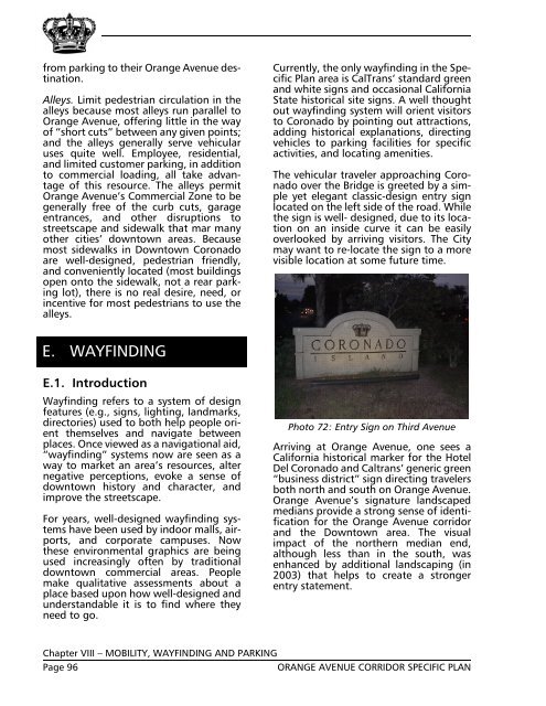
Photo 72: Entry Sign on Third <strong>Avenue</strong><br />
Arriving at <strong>Orange</strong> <strong>Avenue</strong>, one sees a<br />
California historical marker for the Hotel<br />
Del <strong>Coronado</strong> and Caltrans’ generic green<br />
“business district” sign directing travelers<br />
both north and south on <strong>Orange</strong> <strong>Avenue</strong>.<br />
<strong>Orange</strong> <strong>Avenue</strong>’s signature landscaped<br />
medians provide a strong sense <strong>of</strong> identification<br />
for the <strong>Orange</strong> <strong>Avenue</strong> corridor<br />
and the Downtown area. <strong>The</strong> visual<br />
impact <strong>of</strong> the northern median end,<br />
although less than in the south, was<br />
enhanced by additional landscaping (in<br />
2003) that helps to create a stronger<br />
entry statement.<br />
Chapter VIII – MOBILITY, WAYFINDING AND PARKING<br />
Page 96<br />
ORANGE AVENUE CORRIDOR SPECIFIC PLAN