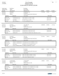
The Orange Avenue Corridor Specific Plan - City of Coronado
The Orange Avenue Corridor Specific Plan - City of Coronado
The Orange Avenue Corridor Specific Plan - City of Coronado

You also want an ePaper? Increase the reach of your titles
YUMPU automatically turns print PDFs into web optimized ePapers that Google loves.
Chapter VIII<br />
MOBILITY, WAYFINDING<br />
AND PARKING<br />
A. INTRODUCTION<br />
This chapter includes non-regulatory<br />
information on vehicular circulation,<br />
transit, bikeways, pedestrian walkways,<br />
wayfinding and parking.<br />
B. VEHICULAR<br />
CIRCULATION<br />
B.1. Existing Conditions<br />
Automobiles are the primary means by<br />
which people access <strong>Coronado</strong>’s Downtown,<br />
and they will continue to be the<br />
primary mode in the foreseeable future. It<br />
should be relatively painless for someone<br />
to get to and from <strong>Coronado</strong>’s Downtown.<br />
Figure VIII-1 (see next page) shows<br />
the roadway classifications in <strong>Coronado</strong><br />
within the <strong>Specific</strong> <strong>Plan</strong> area. <strong>Orange</strong> <strong>Avenue</strong><br />
(designated as State Route 75 south<br />
<strong>of</strong> Third Street), along with Third and<br />
Fourth Streets are principal arterials, with<br />
four lanes <strong>of</strong> traffic. <strong>Orange</strong> <strong>Avenue</strong><br />
north <strong>of</strong> Third Street is a minor arterial,<br />
while First Street, Sixth Street, Tenth<br />
Street and B <strong>Avenue</strong> are two lane collectors.<br />
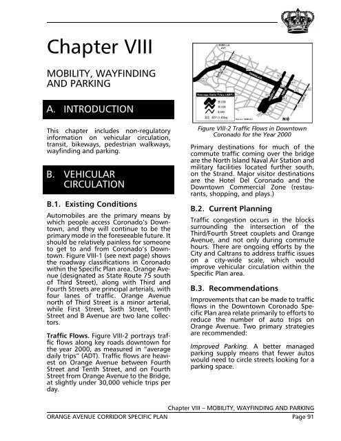
Traffic Flows. Figure VIII-2 portrays traffic<br />
flows along key roads downtown for<br />
the year 2000, as measured in “average<br />
daily trips” (ADT). Traffic flows are heaviest<br />
on <strong>Orange</strong> <strong>Avenue</strong> between Fourth<br />
Street and Tenth Street, and on Fourth<br />
Street from <strong>Orange</strong> <strong>Avenue</strong> to the Bridge,<br />
at slightly under 30,000 vehicle trips per<br />
day.<br />
Figure VIII-2 Traffic Flows in Downtown<br />
<strong>Coronado</strong> for the Year 2000<br />
Primary destinations for much <strong>of</strong> the<br />
commute traffic coming over the bridge<br />
are the North Island Naval Air Station and<br />
military facilities located further south,<br />
on the Strand. Major visitor destinations<br />
are the Hotel Del <strong>Coronado</strong> and the<br />
Downtown Commercial Zone (restaurants,<br />
shopping, and plays.)<br />
B.2. Current <strong>Plan</strong>ning<br />
Traffic congestion occurs in the blocks<br />
surrounding the intersection <strong>of</strong> the<br />
Third/Fourth Street couplets and <strong>Orange</strong><br />
<strong>Avenue</strong>, and not only during commute<br />
hours. <strong>The</strong>re are ongoing efforts by the<br />
<strong>City</strong> and Caltrans to address traffic issues<br />
on a city-wide scale, which would<br />
improve vehicular circulation within the<br />
<strong>Specific</strong> <strong>Plan</strong> area.<br />
B.3. Recommendations<br />
Improvements that can be made to traffic<br />
flows in the Downtown <strong>Coronado</strong> <strong>Specific</strong><br />
<strong>Plan</strong> area relate primarily to efforts to<br />
reduce the number <strong>of</strong> auto trips on<br />
<strong>Orange</strong> <strong>Avenue</strong>. Two primary strategies<br />
are recommended:<br />
Improved Parking. A better managed<br />
parking supply means that fewer autos<br />
would need to circle streets looking for a<br />
parking space.<br />
Chapter VIII – MOBILITY, WAYFINDING AND PARKING<br />
ORANGE AVENUE CORRIDOR SPECIFIC PLAN Page 91