ALOS Data Users Handbook
ALOS Data Users Handbook
ALOS Data Users Handbook

You also want an ePaper? Increase the reach of your titles
YUMPU automatically turns print PDFs into web optimized ePapers that Google loves.
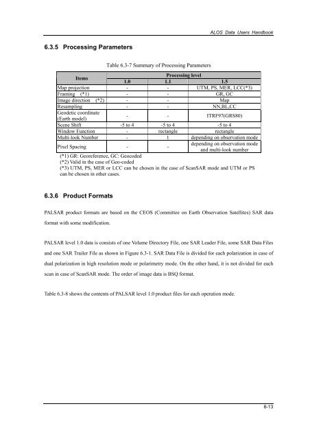
<strong>ALOS</strong> <strong>Data</strong> <strong>Users</strong> <strong>Handbook</strong>6.3.5 Processing ParametersTable 6.3-7 Summary of Processing ParametersItemsProcessing level1.0 1.1 1.5Map projection - - UTM, PS, MER, LCC(*3)Framing (*1) - - GR, GCImage direction (*2) - - MapResampling - - NN,BL,CCGeodetic coordinate(Earth model)- - ITRF97(GRS80)Scene Shift -5 to 4 -5 to 4 -5 to 4Window Function - rectangle rectangleMulti-look Number - 1 depending on observation modePixel Spacing - -depending on observation modeand multi-look number(*1) GR: Georeference, GC: Geocoded(*2) Valid in the case of Geo-coded(*3) UTM, PS, MER or LCC can be chosen in the case of ScanSAR mode and UTM or PScan be chosen in other cases.6.3.6 Product FormatsPALSAR product formats are based on the CEOS (Committee on Earth Observation Satellites) SAR dataformat with some modification.PALSAR level 1.0 data is consists of one Volume Directory File, one SAR Leader File, some SAR <strong>Data</strong> Filesand one SAR Trailer File as shown in Figure 6.3-1. SAR <strong>Data</strong> File is divided for each polarization in case ofdual polarization in high resolution mode or polarimetry mode. On the other hand, it is not divided for eachscan in case of ScanSAR mode. The order of image data is BSQ format.Table 6.3-8 shows the contents of PALSAR level 1.0 product files for each operation mode.6-13


![4.12.2a_Tibet_Wu Guoxiong Tibet-CEOP.ppt[]](https://img.yumpu.com/35802437/1/190x135/4122a-tibet-wu-guoxiong-tibet-ceopppt.jpg?quality=85)