ALOS Data Users Handbook
ALOS Data Users Handbook
ALOS Data Users Handbook
You also want an ePaper? Increase the reach of your titles
YUMPU automatically turns print PDFs into web optimized ePapers that Google loves.
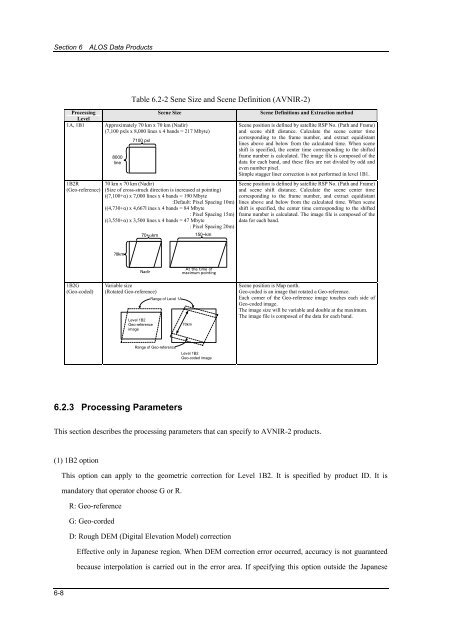
Section 6 <strong>ALOS</strong> <strong>Data</strong> ProductsTable 6.2-2 Sene Size and Scene Definition (AVNIR-2)ProcessingScene SizeLevel1A, 1B1 Approximately 70 km x 70 km (Nadir)(7,100 pxls x 8,000 lines x 4 bands = 217 Mbyte)1B2R(Geo-reference)8000line7100 pxl70 km x 70 km (Nadir)(Size of cross-struck direction is increased at pointing)((7,100+α) x 7,000 lines x 4 bands = 190 Mbyte:Default: Pixel Spacing 10m)((4,730+α) x 4,667l ines x 4 bands = 84 Mbyte: Pixel Spacing 15m)((3,550+α) x 3,500 lines x 4 bands = 47 Mbyte: Pixel Spacing 20m)70+αkm150~kmScene Definitions and Extraction methodScene position is defined by satellite RSP No. (Path and Frame)and scene shift distance. Calculate the scene center timecorresponding to the frame number, and extract equidistantlines above and below from the calculated time. When sceneshift is specified, the center time corresponding to the shiftedframe number is calculated. The image file is composed of thedata for each band, and these files are not divided by odd andeven number pixel.Simple stagger liner correction is not performed in level 1B1.Scene position is defined by satellite RSP No. (Path and Frame)and scene shift distance. Calculate the scene center timecorresponding to the frame number, and extract equidistantlines above and below from the calculated time. When sceneshift is specified, the center time corresponding to the shiftedframe number is calculated. The image file is composed of thedata for each band.70kmNadirAt the time ofmaximum pointing1B2G(Geo-coded)Variable size(Rotated Geo-reference)Level 1B2Geo-referenceimageRange of Level 1A70kmScene position is Map north.Geo-coded is an image that rotated a Geo-reference.Each corner of the Geo-reference image touches each side ofGeo-coded image.The image size will be variable and double at the maximum.The image file is composed of the data for each band.Range of Geo-referenceLevel 1B2Geo-coded image6.2.3 Processing ParametersThis section describes the processing parameters that can specify to AVNIR-2 products.(1) 1B2 optionThis option can apply to the geometric correction for Level 1B2. It is specified by product ID. It ismandatory that operator choose G or R.R: Geo-referenceG: Geo-cordedD: Rough DEM (Digital Elevation Model) correctionEffective only in Japanese region. When DEM correction error occurred, accuracy is not guaranteedbecause interpolation is carried out in the error area. If specifying this option outside the Japanese6-8





![4.12.2a_Tibet_Wu Guoxiong Tibet-CEOP.ppt[]](https://img.yumpu.com/35802437/1/190x135/4122a-tibet-wu-guoxiong-tibet-ceopppt.jpg?quality=85)
