ALOS Data Users Handbook
ALOS Data Users Handbook
ALOS Data Users Handbook

You also want an ePaper? Increase the reach of your titles
YUMPU automatically turns print PDFs into web optimized ePapers that Google loves.
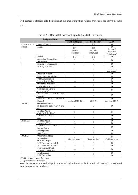
<strong>ALOS</strong> <strong>Data</strong> <strong>Users</strong> <strong>Handbook</strong>With respect to standard data distribution at the time of inputting requests from users are shown in Table8.5-3.Common to AllsensorsPRISMAVNIR-2PALSARTable 8.5-3 Designated Items for Requests (Standard Distribution)Designated ItemsLevel 0ProductsStanding Request Standing Request AUIGName of Sensor [O] [O] [O]Range[O][O][O](latitude/(latitude/(latitude/longitude,longitude) longitude)Path-frame)Period [O] [O] [O]Ascending/DescendingDesignationO O OPurpose of Observation O O OShifting of Scene–– OO(only afterobservation)Direction of Map –– O OMap Projecting Method –– O OUTM Zone Number –– O OResampling Method –– O OOrbit <strong>Data</strong> Accuracy –– O OAttitude<strong>Data</strong> Accuracy –– O OCompression Option(on-line only)PS Baseline Latitude andLongitudeSatellite <strong>Data</strong> ProvisionMethodObservation Mode(3 directions, nadir view 70 kmetc.)–– O O–– O OO(on-line, DTF-2)O(CD-R)O(on-line, CD-R)O O OPointing Angle(Left, Middle, Right)O O OAmount of Cloud –– O OGain O O OPointing Angle O O OAmount of Cloud –– O OLight Exposure CoefficientSetting StatusO O OPixel Spacing –– O OGain Status O O OObservation Mode,OOPolarization,(Table number) (Table number)Off-nadir AngleO(Table number)LCC Baseline Latitude 1 –– O OLCC Baseline Latitude 2 –– O OLCC Original Point,Latitude / Longitude–– O OPixel Spacing –– O OREV Correction O O O[O]: Obrigatory items for input.O: Optional items for input.Note: As the option for earth ellipsoid is standardized to Bessel as the international standard, it is excludedfrom the options for the above.


![4.12.2a_Tibet_Wu Guoxiong Tibet-CEOP.ppt[]](https://img.yumpu.com/35802437/1/190x135/4122a-tibet-wu-guoxiong-tibet-ceopppt.jpg?quality=85)