ALOS Data Users Handbook
ALOS Data Users Handbook
ALOS Data Users Handbook
Create successful ePaper yourself
Turn your PDF publications into a flip-book with our unique Google optimized e-Paper software.
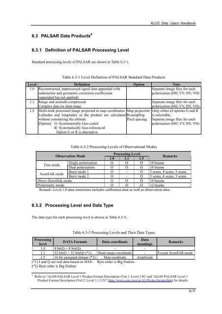
<strong>ALOS</strong> <strong>Data</strong> <strong>Users</strong> <strong>Handbook</strong>6.3 PALSAR <strong>Data</strong> Products 46.3.1 Definition of PALSAR Processing LevelStandard processing levels of PALSAR are shown in Table 6.3-1.Table 6.3-1 Level Definition of PALSAR Standard <strong>Data</strong> ProductsLevel Definition Option Note1.0 Reconstructed, unprocessed signal data appended withradiometric and geometric correction coefficientsSeparate image files for eachpolarization (HH, VV, HV, VH)(appended but not applied)1.1 Range and azimuth compressedSeparate image files for eachComplex data on slant range1.5 Multi-look processed image projected to map coordinates.Latitudes and longitudes in the product are calculatedwithout considering the altitude.[Option] G: Systematically Geo-codedR: Systematically Geo-referencedOption G or R is alternativeMap projectionResamplingPixel spacingpolarization (HH, VV, HV, VH)Only either of options G and Ris selectable.Separate image files for eachpolarization (HH, VV, HV, VH)Table 6.3-2 Processing Levels of Observational ModesObservation ModeProcessing Level1.0 1.1 1.5RemarksFine modeSingle polarization O O O 18 beamsDual polarization O O O 18 beamsScanSAR modeBurst mode 1 O - O 3 scans, 4 scans, 5 scansBurst mode 2 O - O 3 scans, 4 scans, 5 scansDirect Downlink mode O O O 18 beamsPolarimetry mode O O O 12 beamsRemark: Level 1.0 data sometimes includes calibration data as well as observation data.6.3.2 Processing Level and <strong>Data</strong> TypeThe data type for each processing level is shown in Table 6.3-3.Table 6.3-3 Processing Levels and Their <strong>Data</strong> TypesProcessing<strong>Data</strong>DATA Formats <strong>Data</strong> coordinatelevelmeaningsRemarks1.0 8 bit(I) + 8 bit(Q) - -1.1 32 bit(I) + 32 bit(Q) (*1) Slant range coordinate - Except ScanSAR mode1.5 16 bit unsigned integer (*2) Map coodinate Amplitude(*1) I and Q are real data based on IEEE. Byte order is Big Endian.(*2) Byte order is Big Endian4 Refer to “<strong>ALOS</strong> PALSAR Level 1 Product Format Description (Vol.1: Level 1.0)” and “<strong>ALOS</strong> PALSAR Level 1Product Format Description (Vol.2: Level 1.1/1.5)” (http://www.eorc.jaxa.jp/<strong>ALOS</strong>/doc/format.htm) for details.6-11









![4.12.2a_Tibet_Wu Guoxiong Tibet-CEOP.ppt[]](https://img.yumpu.com/35802437/1/190x135/4122a-tibet-wu-guoxiong-tibet-ceopppt.jpg?quality=85)
