ALOS Data Users Handbook
ALOS Data Users Handbook
ALOS Data Users Handbook

You also want an ePaper? Increase the reach of your titles
YUMPU automatically turns print PDFs into web optimized ePapers that Google loves.
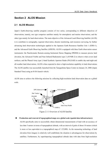
<strong>ALOS</strong> <strong>Data</strong> <strong>Users</strong> <strong>Handbook</strong>Section 2 <strong>ALOS</strong> Mission2.1 <strong>ALOS</strong> MissionJapan’s Earth-observing satellite program consists of two series, corresponding to different objectives ofobservations; namely, one type comprises satellites mainly for atmospheric and marine observations, and theother type mainly for land observations. The main objective of the Advanced Land Observing Satellite (<strong>ALOS</strong>)is to contribute to cartography, regional observation, disaster monitoring, and resources surveying, by furtheradvancing land observation technologies applied to the Japanese Earth Resources Satellite Unit 1 (JERS-1),and the Advanced Earth Observing Satellite (ADEOS). <strong>ALOS</strong> is equipped with three Earth observation sensorinstruments: the Panchromatic Remote-sensing Instrument Stereo Mapping (PRISM) to measure precise landelevation, the Advanced Visible and Near Infrared Radiometer type 2 (AVNIR-2) to observe what covers landsurfaces, and the Phased Array type L-band Synthetic Aperture Radar (PALSAR) to enable day-and-night andall-weather land observations. <strong>ALOS</strong> is thus expected to show a high-resolution capability in land observations.The <strong>ALOS</strong> satellite was successfully launched from the Tanegashima Space Center on January 24, 2006 (JapanStandard Time) using an H-IIA launch vehicle.<strong>ALOS</strong> aims to achieve the following missions by collecting high-resolution land observation data on a globalscale.GPS AntennaIOCS AntennaStar TrackerPALSARPRISMAVNIR-2Solar Array PaddleFigure 2.1-1 Overview of <strong>ALOS</strong> Satellite• Production and renewal of topographical maps on a global scale (spatial data infrastructure):<strong>ALOS</strong> specifically aims to successfully obtain dimensional measurements of land with an accuracy ofless than 5 meters in terms of topographical altitude, with an interval of grids of about 10 meters (whichis more or less equivalent to a topographical map of 1:25,000). As the measuring technology of landelevation from imagery is relatively well established, the situation is advantageous for observations bysatellites. Furthermore, by superimposing topographical altitude data with data from high-resolution2-1


![4.12.2a_Tibet_Wu Guoxiong Tibet-CEOP.ppt[]](https://img.yumpu.com/35802437/1/190x135/4122a-tibet-wu-guoxiong-tibet-ceopppt.jpg?quality=85)