ALOS Data Users Handbook
ALOS Data Users Handbook
ALOS Data Users Handbook

Create successful ePaper yourself
Turn your PDF publications into a flip-book with our unique Google optimized e-Paper software.
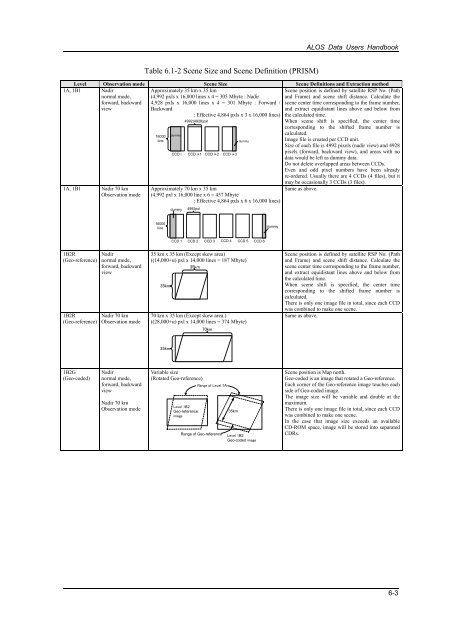
<strong>ALOS</strong> <strong>Data</strong> <strong>Users</strong> <strong>Handbook</strong>Table 6.1-2 Scene Size and Scene Definition (PRISM)Level Observation mode Scene Size Scene Definitions and Extraction method1A, 1B1 Nadirnormal mode,forward, backwardviewApproximately 35 km x 35 km(4,992 pxls x 16,000 lines x 4 = 305 Mbyte : Nadir4,928 pxls x 16,000 lines x 4 = 301 Mbyte : Forward /Backward1A, 1B1 Nadir 70 kmObservation mode16000linedummy: Effective 4,864 pxls x 3 x 16,000 lines)4992(4928)pxlCCD i CCD i+1 CCD i+2 CCD i+3dummyApproximately 70 km x 35 km(4,992 pxl x 16,000 line x 6 = 457 Mbyte: Effective 4,864 pxls x 6 x 16,000 lines)dummy4992pxlScene position is defined by satellite RSP No. (Pathand Frame) and scene shift distance. Calculate thescene center time corresponding to the frame number,and extract equidistant lines above and below fromthe calculated time.When scene shift is specified, the center timecorresponding to the shifted frame number iscalculated.Image file is created per CCD unit.Size of each file is 4992 pixels (nadir view) and 4928pixels (forward, backward view), and areas with nodata would be left as dummy data.Do not delete overlapped areas between CCDs.Even and odd pixel numbers have been alreadyre-ordered. Usually there are 4 CCDs (4 files), but itmay be occasionally 3 CCDs (3 files).Same as above.16000linedummyCCD 1 CCD 2 CCD 3 CCD 4 CCD 5 CCD 61B2R(Geo-reference)1B2R(Geo-reference)Nadirnormal mode,forward, backwardviewNadir 70 kmObservation mode35 km x 35 km (Except skew area)((14,000+α) pxl x 14,000 lines = 187 Mbyte)35km35km70 km x 35 km (Except skew area.)((28,000+α) pxl x 14,000 lines = 374 Mbyte)70kmScene position is defined by satellite RSP No. (Pathand Frame) and scene shift distance. Calculate thescene center time corresponding to the frame number,and extract equidistant lines above and below fromthe calculated time.When scene shift is specified, the center timecorresponding to the shifted frame number iscalculated.There is only one image file in total, since each CCDwas combined to make one scene.Same as above.35km1B2G(Geo-coded)Nadirnormal mode,forward, backwardviewNadir 70 kmObservation modeVariable size(Rotated Geo-reference)Level 1B2Geo-referenceimageRange of Level 1ARange of Geo-reference35kmLevel 1B2Geo-coded imageScene position is Map north.Geo-coded is an image that rotated a Geo-reference.Each corner of the Geo-reference image touches eachside of Geo-coded image.The image size will be variable and double at themaximum.There is only one image file in total, since each CCDwas combined to make one scene.In the case that image size exceeds an availableCD-ROM space, image will be stored into separatedCDRs.6-3


![4.12.2a_Tibet_Wu Guoxiong Tibet-CEOP.ppt[]](https://img.yumpu.com/35802437/1/190x135/4122a-tibet-wu-guoxiong-tibet-ceopppt.jpg?quality=85)