ALOS Data Users Handbook
ALOS Data Users Handbook
ALOS Data Users Handbook
Create successful ePaper yourself
Turn your PDF publications into a flip-book with our unique Google optimized e-Paper software.
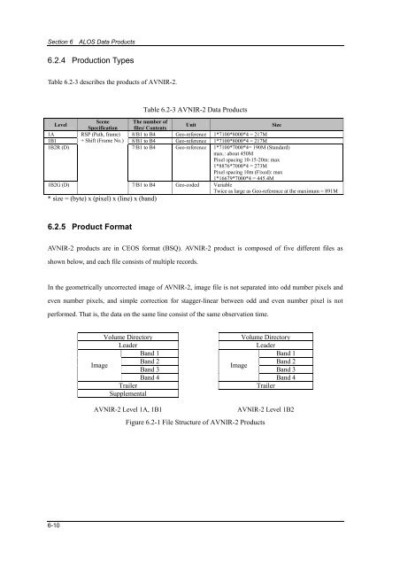
Section 6 <strong>ALOS</strong> <strong>Data</strong> Products6.2.4 Production TypesTable 6.2-3 describes the products of AVNIR-2.Table 6.2-3 AVNIR-2 <strong>Data</strong> ProductsLevelScene The number ofSpecification files/ ContentsUnitSize1A RSP (Path, frame) 8/B1 to B4 Geo-reference 1*7100*8000*4 = 217M1B1 + Shift (Frame No.) 8/B1 to B4 Geo-reference 1*7100*8000*4 = 217M1B2R (D) 7/B1 to B4 Geo-reference 1*7100*7000*4= 190M (Standard)max.: about 450MPixel spacing 10-15-20m: max1*8876*7000*4 = 273MPixel spacing 10m (Fixed): max1*16679*7000*4 = 445.4M1B2G (D)7/B1 to B4 Geo-coded VariableTwice as large as Geo-reference at the maximum = 891M* size = (byte) x (pixel) x (line) x (band)6.2.5 Product FormatAVNIR-2 products are in CEOS format (BSQ). AVNIR-2 product is composed of five different files asshown below, and each file consists of multiple records.In the geometrically uncorrected image of AVNIR-2, image file is not separated into odd number pixels andeven number pixels, and simple correction for stagger-linear between odd and even number pixel is notperformed. That is, the data on the same line consist of the same observation time.Volume DirectoryVolume DirectoryLeaderLeaderBand 1 Band 1ImageBand 2 Band 2ImageBand 3 Band 3Band 4Band 4TrailerTrailerSupplementalAVNIR-2 Level 1A, 1B1AVNIR-2 Level 1B2Figure 6.2-1 File Structure of AVNIR-2 Products6-10









![4.12.2a_Tibet_Wu Guoxiong Tibet-CEOP.ppt[]](https://img.yumpu.com/35802437/1/190x135/4122a-tibet-wu-guoxiong-tibet-ceopppt.jpg?quality=85)
