Tuolumne River Report - U.S. Fish and Wildlife Service
Tuolumne River Report - U.S. Fish and Wildlife Service
Tuolumne River Report - U.S. Fish and Wildlife Service

Create successful ePaper yourself
Turn your PDF publications into a flip-book with our unique Google optimized e-Paper software.
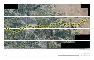
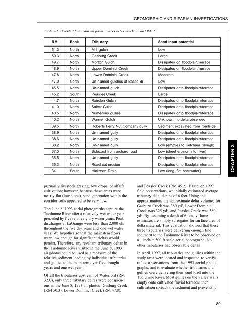
GEOMORPHIC AND RIPARIAN INVESTIGATIONSTable 3-5. Potential fine sediment point sources between RM 32 <strong>and</strong> RM 52.RM Bank Tributary S<strong>and</strong> input potential51.3 North Mill gulch Low50.3 North Gasburg Creek Large49.7 North Morton Gulch Dissipates on floodplain/terrace48.9 North Upper Dominici Creek Dissipates on floodplain/terrace47.8 North Lower Dominici Creek Moderate47.0 North Un-named gulches at Basso Br Low45.5 North Un-named gulch Dissipates onto floodplain/terrace45.2 South Peaslee Creek Large44.7 North Rairden Gulch Dissipates onto floodplain/terrace41.0 North Salter Gulch Dissipates onto floodplain/terrace40.5 North Numerous gullies Dissipates onto floodplain/terrace40.2 North Warner Gulch Unknown, no delta observed39.5 North Roberts Ferry Nut Company gully Sediment excavated from roadside38.9 North Un-named gully Dissipates onto floodplain/terrace38.6 North Un-named gully Dissipates onto floodplain/terrace38.2 North Un-named gully Low (empties to Ketcham Slough)37.0 North Sidecast from orchard road Low (sheet erosion into river)35.5 North Un-named gully Dissipates onto floodplain/terrace35.3 North Road cut erosion Dissipates onto floodplain/terrace34 South Hickman Drain Low (long, flat backwater)CHAPTER 3primarily livestock grazing, row crops, or alfalfacultivation; however, because these areas werenearly flat (low slope), s<strong>and</strong> generation within thecorridor soils appeared to be very low.The June 8, 1993 aerial photographs capture the<strong>Tuolumne</strong> <strong>River</strong> after a relatively wet water yearpreceded by five relatively dry water years. Peakdischarges at LaGrange were less than 2,000 cfsthroughout the five dry years <strong>and</strong> one wet wateryear. We hypothesize that the mainstem flowswere low enough for significant deltas wouldpersist. Therefore, any resultant tributary deltas inthe <strong>Tuolumne</strong> <strong>River</strong> visible in the June 8, 1993air photos could be used as a measure of therelative sediment loading by individual tributaries<strong>and</strong> gullies to the mainstem over five droughtyears <strong>and</strong> one wet year.Of all the tributaries upstream of Waterford (RM32.0), only three tributary deltas were conspicuousin the June 8, 1993 air photos: Gasburg Creek(RM 50.3), Lower Dominici Creek (RM 47.8),<strong>and</strong> Peaslee Creek (RM 45.2). Based on 1997field observations, we initially estimated averagetributary delta depths of 6 feet. Using thisapproximation, the approximate delta volumes forGasburg Creek was 380 yd 3 , Lower DominiciCreek was 325 yd 3 , <strong>and</strong> Peaslee Creek was 380yd 3 . By assuming a depth of 6 feet, volumeestimates are simply surrogates for surface area ofdelta material. This evaluation showed that thesethree tributaries were delivering enough finesediment to the <strong>Tuolumne</strong> <strong>River</strong> to be observed ona 1 inch = 500 ft scale aerial photograph. Noother tributaries had observable deltas.In April 1997, all tributaries <strong>and</strong> gullies within thestudy area were located <strong>and</strong> inspected to verify/refute observations from the 1993 aerial photographs,<strong>and</strong> to evaluate whether tributaries <strong>and</strong>gullies were delivering their s<strong>and</strong> load into the<strong>Tuolumne</strong> <strong>River</strong>. Most gullies on the valley wallsempty onto cultivated fluvial terraces; thencultivation spreads the sediment <strong>and</strong> prevents it89