Tuolumne River Report - U.S. Fish and Wildlife Service
Tuolumne River Report - U.S. Fish and Wildlife Service
Tuolumne River Report - U.S. Fish and Wildlife Service

Create successful ePaper yourself
Turn your PDF publications into a flip-book with our unique Google optimized e-Paper software.
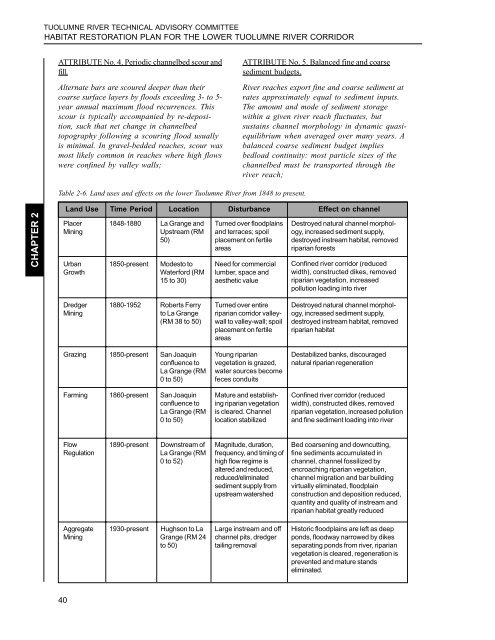
TUOLUMNE RIVER TECHNICAL ADVISORY COMMITTEEHABITAT RESTORATION PLAN FOR THE LOWER TUOLUMNE RIVER CORRIDORATTRIBUTE No. 4. Periodic channelbed scour <strong>and</strong>fill.Alternate bars are scoured deeper than theircoarse surface layers by floods exceeding 3- to 5-year annual maximum flood recurrences. Thisscour is typically accompanied by re-deposition,such that net change in channelbedtopography following a scouring flood usuallyis minimal. In gravel-bedded reaches, scour wasmost likely common in reaches where high flowswere confined by valley walls;ATTRIBUTE No. 5. Balanced fine <strong>and</strong> coarsesediment budgets.<strong>River</strong> reaches export fine <strong>and</strong> coarse sediment atrates approximately equal to sediment inputs.The amount <strong>and</strong> mode of sediment storagewithin a given river reach fluctuates, butsustains channel morphology in dynamic quasiequilibriumwhen averaged over many years. Abalanced coarse sediment budget impliesbedload continuity: most particle sizes of thechannelbed must be transported through theriver reach;Table 2-6. L<strong>and</strong> uses <strong>and</strong> effects on the lower <strong>Tuolumne</strong> <strong>River</strong> from 1848 to present.CHAPTER 2L<strong>and</strong> Use Time Period Location Disturbance Effect on channelPlacerMiningUrbanGrowth1848-1880 La Grange <strong>and</strong>Upstream (RM50)1850-presentModesto toWaterford (RM15 to 30)Turned over floodplains<strong>and</strong> terraces; spoilplacement on fertileareasNeed for commerciallumber, space <strong>and</strong>aesthetic valueDestroyed natural channel morphology,increased sediment supply,destroyed instream habitat, removedriparian forestsConfined river corridor (reducedwidth), constructed dikes, removedriparian vegetation, increasedpollution loading into riverDredgerMining1880-1952 Roberts Ferryto La Grange(RM 38 to 50)Turned over entireriparian corridor valleywallto valley-wall; spoilplacement on fertileareasDestroyed natural channel morphology,increased sediment supply,destroyed instream habitat, removedriparian habitatGrazing 1850-present San Joaquinconfluence toLa Grange (RM0 to 50)Farming 1860-present San Joaquinconfluence toLa Grange (RM0 to 50)Young riparianvegetation is grazed,water sources becomefeces conduitsMature <strong>and</strong> establishingriparian vegetationis cleared. Channellocation stabilizedDestabilized banks, discouragednatural riparian regenerationConfined river corridor (reducedwidth), constructed dikes, removedriparian vegetation, increased pollution<strong>and</strong> fine sediment loading into riverFlowRegulation1890-presentDownstream ofLa Grange (RM0 to 52)Magnitude, duration,frequency, <strong>and</strong> timing ofhigh flow regime isaltered <strong>and</strong> reduced,reduced/eliminatedsediment supply fromupstream watershedBed coarsening <strong>and</strong> downcutting,fine sediments accumulated inchannel, channel fossilized byencroaching riparian vegetation,channel migration <strong>and</strong> bar buildingvirtually eliminated, floodplainconstruction <strong>and</strong> deposition reduced,quantity <strong>and</strong> quality of instream <strong>and</strong>riparian habitat greatly reducedAggregateMining1930-presentHughson to LaGrange (RM 24to 50)Large instream <strong>and</strong> offchannel pits, dredgertailing removalHistoric floodplains are left as deepponds, floodway narrowed by dikesseparating ponds from river, riparianvegetation is cleared, regeneration isprevented <strong>and</strong> mature st<strong>and</strong>seliminated.40