Tuolumne River Report - U.S. Fish and Wildlife Service
Tuolumne River Report - U.S. Fish and Wildlife Service
Tuolumne River Report - U.S. Fish and Wildlife Service

You also want an ePaper? Increase the reach of your titles
YUMPU automatically turns print PDFs into web optimized ePapers that Google loves.
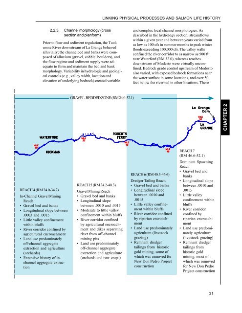
LINKING PHYSICAL PROCESSES AND SALMON LIFE HISTORY2.2.3. Channel morphology (crosssection <strong>and</strong> planform)Prior to flow <strong>and</strong> sediment regulation, the <strong>Tuolumne</strong><strong>River</strong> downstream of La Grange behavedalluvially; the channelbed <strong>and</strong> banks were composedof alluvium (gravel, cobble, boulders), <strong>and</strong>the flow regime <strong>and</strong> sediment supply were adequateto form <strong>and</strong> maintain the bed <strong>and</strong> bankmorphology. Variability in hydrologic <strong>and</strong> geologicalcontrols (e.g., valley width, location <strong>and</strong>elevation of underlying bedrock) created variable<strong>and</strong> complex local channel morphologies. Asdescribed in the hydrology section, streamflowswithin a given year <strong>and</strong> between years varied fromas low as 100 cfs in summer months to peak winterfloods exceeding 100,000 cfs. The valley wallsconfined the river corridor to as narrow as 500 ftnear Waterford (RM 32.0), whereas reachesdownstream of Modesto were virtually unconfined.Bedrock grade control upstream of Modestoalso varied, with exposed bedrock formations nearthe water surface in some locations, <strong>and</strong> over 50feet below the riverbed in other locations. TheseGRAVEL-BEDDED ZONE (RM 24.0-52.1)CHAPTER 2REACH 7(RM 46.6-52.1)Dominant SpawningReach• Gravel bed <strong>and</strong>banks• Longitudinal slopebetween .0010 <strong>and</strong>.0015• Little valleyconfinement withinbluffs• <strong>River</strong> corridorconfined byriparian encroachment• L<strong>and</strong> use predominatelyagriculture(livestock grazing)• Remnant dredgertailings fromhistoric goldmining, most ofwhich was removedfor New Don PedroProject constructionREACH 4 (RM 24.0-34.2)In-Channel Gravel MiningReach• Gravel bed <strong>and</strong> banks• Longitudinal slope between.0003 <strong>and</strong> .0015• Little valley confinementwithin bluffs• <strong>River</strong> corridor confined byagricultural encroachment• L<strong>and</strong> use predominatelyoff-channel aggregateextraction <strong>and</strong> agriculture(orchards)• Extensive history of inchannelaggregate extractionREACH 5 (RM 34.2-40.3)Gravel Mining Reach• Gravel bed <strong>and</strong> banks• Longitudinal slopebetween .0010 <strong>and</strong> .0015• Moderate to little valleyconfinement within bluffs• <strong>River</strong> corridor confinedby agricultural encroachment<strong>and</strong> dikes separatingriver from off-channelmining pits• L<strong>and</strong> use predominatelyoff-channel aggregateextraction <strong>and</strong> agriculture(orchards <strong>and</strong> row crops)REACH 6 (RM 40.3-46.6)Dredger Tailing Reach• Gravel bed <strong>and</strong> banks• Longitudinal slopebetween .0010 <strong>and</strong>.0015• Little valley confinementwithin bluffs• <strong>River</strong> corridor confinedby riparian encroachment• L<strong>and</strong> use predominatelyagriculture (livestockgrazing)• Remnant dredgertailings from historicgold mining, some ofwhich was removed forNew Don Pedro Projectconstruction31