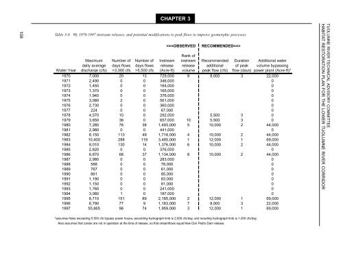
CHAPTER 3108Table 3-8. Wy 1970-1997 instream releases, <strong>and</strong> potential modifications to peak flows to improve geomorphic processes.Rank ofMaximum Number of Number of Instream instream Recommended Duration Additional waterdaily average days flows days flows release release additional of peak volume bypassingWater Year discharge (cfs) >3,000 cfs >5,500 cfs (Acre-ft) volume peak flow (cfs) flow (days) power plant (Acre-ft)*1970 7,000 20 13 729,000 9 8,000 3 22,0001971 2,490 0 0 346,000 01972 1,450 0 0 164,000 01973 1,370 0 0 165,000 01974 1,940 0 0 376,000 01975 3,080 2 0 561,000 01976 2,730 0 0 360,000 01977 224 0 0 67,000 01978 4,570 10 0 292,000 5,500 3 01979 3,650 36 0 657,000 10 5,500 3 01980 7,280 76 38 1,493,000 5 10,000 2 44,0001981 2,980 0 0 441,000 01982 8,150 113 49 1,718,000 4 10,000 2 44,0001983 10,400 288 118 3,465,000 1 12,000 1 69,0001984 8,010 130 14 1,376,000 6 10,000 2 44,0001985 2,820 0 0 376,000 01986 6,870 68 37 1,134,000 8 10,000 2 44,0001987 2,980 0 0 283,000 01988 588 0 0 78,000 01989 767 0 0 61,000 01990 861 0 0 85,000 01991 1,190 0 0 83,000 01992 1,150 0 0 81,000 01993 1,760 0 0 241,000 01994 3,080 1 0 187,000 01995 8,710 151 89 2,185,000 2 12,000 1 69,0001996 6,790 77 9 1,183,000 7 8,000 3 22,0001997 55,865 96 74 1,959,000 3 12,000 1 69,000TUOLUMNE RIVER TECHNICAL ADVISORY COMMITTEEHABITAT RESTORATION PLAN FOR THE LOWER TUOLUMNE RIVER CORRIDOR*assumes flows exceeding 5,500 cfs bypass power house, ascending hydrograph limb is 2,000 cfs/day, <strong>and</strong> receding hydrograph limb is 1,000 cfs/day.Also assumes that canals are not in operation at the time of release, so that streamflows equal New Don Pedro Dam release.
GEOMORPHIC AND RIPARIAN INVESTIGATIONS• If possible, extend the duration of flows in the5,500 cfs range for several days after the peakflow event to transport fine sediment downstream<strong>and</strong> deposit onto contemporary floodplains(designed to inundate at 4,000 cfs to5,000 cfs).• Larger releases (e.g., 12,000 cfs) should be ofprogressively shorter duration due minimizecoarse sediment transport capacity <strong>and</strong> attenuatehigh flow peak magnitudes in downstreamurban areas. Initial suggestions for high flowduration for 8,000 cfs, 10,000 cfs, <strong>and</strong> 12,000cfs fluvial geomorphic releases are 3-day, 2-day,<strong>and</strong> 1-day duration respectively to minimizedownstream gravel flux while exceeding bedmobility thresholds (Figures 3-22 to 3-29).• Down-ramping rates should be at, or lower than,rates specified in the FSA <strong>and</strong> ACOE floodcontrol manual to minimize juvenile chinooksalmon str<strong>and</strong>ing.• Years in which flood management releases arenecessary tend to come in multi-year sequences;therefore, in the first wet year after severalsequential dryer years, a larger flow should bereleased if feasible (e.g., 12,000 cfs) to reverseriparian seedling initiation on active channelalluvial deposits, reducing riparian encroachmentrisk.• The magnitude <strong>and</strong> duration of these flowsshould be re-evaluated continuously as part ofthe adaptive management program to evaluatewhether bed mobility, bedload transport, s<strong>and</strong>transport, channel migration, <strong>and</strong> bed scourobjectives are being met.• Extremely wet years with extensive floodcontrol releases in the spring should target verygradual ramping rates to encourage riparianregeneration on contemporary floodplains.Ramping rates targeting natural Fremontcottonwood regeneration should be less than 3cm/day to allow their taproots to follow thedescending moist capillary fringe.These recommendations were developed to avoidinterference with water allocations contained inthe FERC Settlement Agreement, <strong>and</strong> to minimizeloss of power generation revenues whenbypass flows would normally occur. We suggestthat geomorphic <strong>and</strong> biological monitoringexperiments be developed <strong>and</strong> implemented (e.g.,impacts of flow magnitude <strong>and</strong> duration to reddscour <strong>and</strong> egg mortality) prior to each winterseason, in the event flood management releasesoccur. We recommend that the TRTAC closelymonitor whether flood flows are achieving fluvialgeomorphic <strong>and</strong> biological restoration objectives.The most significant potential shortcoming of theabove approach is long sequences of dryer years(1971-1977, 1987-1994) that allow riparianvegetation to initiate <strong>and</strong> establish on newlyrehabilitated reaches <strong>and</strong> newly deposited alluvialsurfaces.3.2.3. Constraints (sediment supply,floodway width, structuralencroachment)One result of the January 3, 1997 flood peak wasthe immediate perception that we needed to dosomething to prevent this from happening again.Some commonly suggested immediate solutionshave been more storage (more or bigger dams),levees, or purchasing more flood control space inexisting reservoirs. Out of this reactionary noiseemerged a solution that could benefit a variety ofneeds: increased floodway capacity to improveflood management <strong>and</strong> flood control flexibility.There are several primary considerations whenconsidering flood management solutions: maintainagricultural <strong>and</strong> municipal water supplies,providing flood control, protecting private <strong>and</strong>public property, ensuring human safety, positive<strong>and</strong> negative impacts to the environment, <strong>and</strong>cost. Purchasing flood control space in NDPPprovides additional flood control protection, butreduces water supply, imposes a large cost to thepublic, <strong>and</strong> reduces environmental benefitsprovided by higher flood control releases.Constructing levees can contain floods, but theyoften provide a false-protection by allowingdevelopment behind them, <strong>and</strong> when they fail,flood damage increases. Additionally, the cost oflevee construction <strong>and</strong> maintenance is large <strong>and</strong>greatly reduces the environmental quality of theriver corridor.A logical, long-term solution is to restore acontinuous floodway <strong>and</strong> me<strong>and</strong>er corridor fromLa Grange downstream to the San Joaquin <strong>River</strong>that provides flood conveyance up to 15,000 cfsupstream of Dry Creek <strong>and</strong> 20,000 cfs to the SanJoaquin <strong>River</strong>. This strategy is integral to restoringfluvial geomorphic processes to the <strong>Tuolumne</strong><strong>River</strong>, while at the same time reducing the risk ofcatastrophic floods (e.g., 1997 flood), greatlyimproves salmon habitat, provides property <strong>and</strong>human protection, preserves agricultural <strong>and</strong>municipal water supplies, <strong>and</strong> provides operatorsCHAPTER 3109
- Page 1 and 2:
Habitat Restoration Plan for theLow
- Page 4 and 5:
TUOLUMNE RIVER TECHNICAL ADVISORY C
- Page 6 and 7:
TUOLUMNE RIVER TECHNICAL ADVISORY C
- Page 8 and 9:
TUOLUMNE RIVER TECHNICAL ADVISORY C
- Page 10 and 11:
TUOLUMNE RIVER TECHNICAL ADVISORY C
- Page 12 and 13:
TUOLUMNE RIVER TECHNICAL ADVISORY C
- Page 14 and 15:
TUOLUMNE RIVER TECHNICAL ADVISORY C
- Page 16 and 17:
TUOLUMNE RIVER TECHNICAL ADVISORY C
- Page 18 and 19:
TUOLUMNE RIVER TECHNICAL ADVISORY C
- Page 20 and 21:
TUOLUMNE RIVER TECHNICAL ADVISORY C
- Page 22 and 23:
TUOLUMNE RIVER TECHNICAL ADVISORY C
- Page 24 and 25:
TUOLUMNE RIVER TECHNICAL ADVISORY C
- Page 26 and 27:
TUOLUMNE RIVER TECHNICAL ADVISORY C
- Page 28 and 29:
TUOLUMNE RIVER TECHNICAL ADVISORY C
- Page 30 and 31:
TUOLUMNE RIVER TECHNICAL ADVISORY C
- Page 32 and 33:
TUOLUMNE RIVER TECHNICAL ADVISORY C
- Page 34 and 35:
TUOLUMNE RIVER TECHNICAL ADVISORY C
- Page 36 and 37:
TUOLUMNE RIVER TECHNICAL ADVISORY C
- Page 38 and 39:
TUOLUMNE RIVER TECHNICAL ADVISORY C
- Page 40 and 41:
TUOLUMNE RIVER TECHNICAL ADVISORY C
- Page 42 and 43:
TUOLUMNE RIVER TECHNICAL ADVISORY C
- Page 44 and 45:
TUOLUMNE RIVER TECHNICAL ADVISORY C
- Page 46 and 47:
TUOLUMNE RIVER TECHNICAL ADVISORY C
- Page 48 and 49:
TUOLUMNE RIVER TECHNICAL ADVISORY C
- Page 50 and 51:
CHAPTER 226Table 2-5. Revised minim
- Page 52 and 53:
TUOLUMNE RIVER TECHNICAL ADVISORY C
- Page 54 and 55:
TUOLUMNE RIVER TECHNICAL ADVISORY C
- Page 56 and 57:
TUOLUMNE RIVER TECHNICAL ADVISORY C
- Page 58 and 59:
TUOLUMNE RIVER TECHNICAL ADVISORY C
- Page 60 and 61:
CHAPTER 2TUOLUMNE RIVER TECHNICAL A
- Page 62 and 63:
TUOLUMNE RIVER TECHNICAL ADVISORY C
- Page 64 and 65:
TUOLUMNE RIVER TECHNICAL ADVISORY C
- Page 66 and 67:
TUOLUMNE RIVER TECHNICAL ADVISORY C
- Page 68 and 69:
CHAPTER 2TUOLUMNE RIVER TECHNICAL A
- Page 70 and 71:
TUOLUMNE RIVER TECHNICAL ADVISORY C
- Page 72 and 73:
TUOLUMNE RIVER TECHNICAL ADVISORY C
- Page 74 and 75:
TUOLUMNE RIVER TECHNICAL ADVISORY C
- Page 76 and 77:
TUOLUMNE RIVER TECHNICAL ADVISORY C
- Page 78 and 79:
TUOLUMNE RIVER TECHNICAL ADVISORY C
- Page 80 and 81:
TUOLUMNE RIVER TECHNICAL ADVISORY C
- Page 82 and 83: TUOLUMNE RIVER TECHNICAL ADVISORY C
- Page 84 and 85: TUOLUMNE RIVER TECHNICAL ADVISORY C
- Page 86 and 87: TUOLUMNE RIVER TECHNICAL ADVISORY C
- Page 88 and 89: TUOLUMNE RIVER TECHNICAL ADVISORY C
- Page 90 and 91: TUOLUMNE RIVER TECHNICAL ADVISORY C
- Page 92 and 93: TUOLUMNE RIVER TECHNICAL ADVISORY C
- Page 94 and 95: TUOLUMNE RIVER TECHNICAL ADVISORY C
- Page 96 and 97: TUOLUMNE RIVER TECHNICAL ADVISORY C
- Page 98 and 99: TUOLUMNE RIVER TECHNICAL ADVISORY C
- Page 100 and 101: TUOLUMNE RIVER TECHNICAL ADVISORY C
- Page 102 and 103: TUOLUMNE RIVER TECHNICAL ADVISORY C
- Page 104 and 105: TUOLUMNE RIVER TECHNICAL ADVISORY C
- Page 106 and 107: TUOLUMNE RIVER TECHNICAL ADVISORY C
- Page 108 and 109: TUOLUMNE RIVER TECHNICAL ADVISORY C
- Page 110 and 111: TUOLUMNE RIVER TECHNICAL ADVISORY C
- Page 112 and 113: TUOLUMNE RIVER TECHNICAL ADVISORY C
- Page 114 and 115: TUOLUMNE RIVER TECHNICAL ADVISORY C
- Page 116 and 117: TUOLUMNE RIVER TECHNICAL ADVISORY C
- Page 118 and 119: TUOLUMNE RIVER TECHNICAL ADVISORY C
- Page 120 and 121: TUOLUMNE RIVER TECHNICAL ADVISORY C
- Page 122 and 123: TUOLUMNE RIVER TECHNICAL ADVISORY C
- Page 124 and 125: CHAPTER 3100Elevation (ft)110105100
- Page 126 and 127: TUOLUMNE RIVER TECHNICAL ADVISORY C
- Page 128 and 129: CHAPTER 3104Elevation (ft)195190185
- Page 130 and 131: TUOLUMNE RIVER TECHNICAL ADVISORY C
- Page 134 and 135: TUOLUMNE RIVER TECHNICAL ADVISORY C
- Page 136 and 137: TUOLUMNE RIVER TECHNICAL ADVISORY C
- Page 138 and 139: TUOLUMNE RIVER TECHNICAL ADVISORY C
- Page 140 and 141: TUOLUMNE RIVER TECHNICAL ADVISORY C
- Page 142 and 143: TUOLUMNE RIVER TECHNICAL ADVISORY C
- Page 144 and 145: TUOLUMNE RIVER TECHNICAL ADVISORY C
- Page 146 and 147: TUOLUMNE RIVER TECHNICAL ADVISORY C
- Page 148 and 149: TUOLUMNE RIVER TECHNICAL ADVISORY C
- Page 150 and 151: TUOLUMNE RIVER TECHNICAL ADVISORY C
- Page 152 and 153: TUOLUMNE RIVER TECHNICAL ADVISORY C
- Page 154 and 155: TUOLUMNE RIVER TECHNICAL ADVISORY C
- Page 156 and 157: TUOLUMNE RIVER TECHNICAL ADVISORY C
- Page 158 and 159: 134Relative elevation (ft)140130120
- Page 160 and 161: CHAPTER 3136Relative elevation (ft)
- Page 162 and 163: TUOLUMNE RIVER TECHNICAL ADVISORY C
- Page 164 and 165: TUOLUMNE RIVER TECHNICAL ADVISORY C
- Page 166 and 167: TUOLUMNE RIVER TECHNICAL ADVISORY C
- Page 168 and 169: TUOLUMNE RIVER TECHNICAL ADVISORY C
- Page 170 and 171: TUOLUMNE RIVER TECHNICAL ADVISORY C
- Page 172 and 173: TUOLUMNE RIVER TECHNICAL ADVISORY C
- Page 174 and 175: TUOLUMNE RIVER TECHNICAL ADVISORY C
- Page 176 and 177: TUOLUMNE RIVER TECHNICAL ADVISORY C
- Page 178 and 179: TUOLUMNE RIVER TECHNICAL ADVISORY C
- Page 180 and 181: TUOLUMNE RIVER TECHNICAL ADVISORY C
- Page 182 and 183:
TUOLUMNE RIVER TECHNICAL ADVISORY C
- Page 184 and 185:
TUOLUMNE RIVER TECHNICAL ADVISORY C
- Page 186 and 187:
TUOLUMNE RIVER TECHNICAL ADVISORY C
- Page 188 and 189:
TUOLUMNE RIVER TECHNICAL ADVISORY C
- Page 190 and 191:
TUOLUMNE RIVER TECHNICAL ADVISORY C
- Page 192 and 193:
TUOLUMNE RIVER TECHNICAL ADVISORY C
- Page 194 and 195:
ADAPTIVE MANAGEMENT5. ADAPTIVE MANA
- Page 196 and 197:
ADAPTIVE MANAGEMENTmonitoring progr
- Page 198 and 199:
ADAPTIVE MANAGEMENTWILDLIFE POPULAT
- Page 200 and 201:
ADAPTIVE MANAGEMENT• Distribution
- Page 202 and 203:
REFERENCESREFERENCESAlderdice, D. F
- Page 204 and 205:
REFERENCESKjelson, M. A., P. F. Raq
- Page 206 and 207:
REFERENCESTID (Turlock Irrigation D
- Page 208 and 209:
APPENDIX AAPPENDIX AANNUAL HYDROGRA
- Page 210 and 211:
APPENDIX A30,00028,00026,00024,0002
- Page 212 and 213:
APPENDIX A30,00028,00026,00024,0002
- Page 214 and 215:
APPENDIX A30,00028,00026,00024,0002
- Page 216 and 217:
APPENDIX A30,00028,00026,00024,0002
- Page 218 and 219:
APPENDIX A30,00028,00026,00024,0002
- Page 220 and 221:
APPENDIX A30,00028,00026,00024,0002
- Page 222 and 223:
APPENDIX A30,00028,00026,00024,0002
- Page 224 and 225:
APPENDIX A30,00028,00026,00024,0002
- Page 226 and 227:
APPENDIX A30,00028,00026,00024,0002
- Page 228 and 229:
APPENDIX A30,00028,00026,00024,0002
- Page 230 and 231:
APPENDIX BAPPENDIX BTUOLUMNE RIVER
- Page 232 and 233:
VEGETATION SERIESNATURAL DIVERSITY
- Page 234 and 235:
VEGETATION SERIESNATURAL DIVERSITY
- Page 236 and 237:
Nature Conservancy Heritage Program
- Page 238 and 239:
215Scientific Name Common Name Loca
- Page 240:
APPENDIX BAPPENDIX B217