Tuolumne River Report - U.S. Fish and Wildlife Service
Tuolumne River Report - U.S. Fish and Wildlife Service
Tuolumne River Report - U.S. Fish and Wildlife Service

Create successful ePaper yourself
Turn your PDF publications into a flip-book with our unique Google optimized e-Paper software.
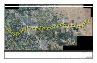
LINKING PHYSICAL PROCESSES AND SALMON LIFE HISTORYbut occasionally reaching as long as 4,000 ft.Me<strong>and</strong>ers typically had low amplitude (< 400 ft)<strong>and</strong> large radius of curvature (>1,500 ft), <strong>and</strong> thechannel form was a combination of single-thread<strong>and</strong> split channels (mild braiding) (Figure 2-19).Channel movement appears to have been dominatedby a combination of channel avulsion <strong>and</strong>channel migration.2.2.3.2. Historical channel morphology ins<strong>and</strong>-bedded zoneThe sharp transition from gravel-bedded to s<strong>and</strong>beddedriver downstream of Geer Road (RM 24)caused a notable shift in channel morphology: inthe s<strong>and</strong>-bedded zone the channel was almostentirely single thread, <strong>and</strong> alternate bars approachedthe idealized pattern (Figure 2-18).Bankfull widths estimated from the 1937 airphotos were approximately 600 ft. Me<strong>and</strong>erwavelengths were much less variable than in thegravel-bedded zone, tending toward 3,000 ft. Theamplitude of me<strong>and</strong>ers was much higher than thegravel-bedded zone, ranging from 600 ft near RM23 to 750 ft near present-day Shiloh Bridge (RM3.5). Channel movement in this zone appearstypical of Midwestern s<strong>and</strong>-bedded streams (e.g.,Mississippi <strong>River</strong>), where progressive channelmigration increased me<strong>and</strong>er amplitude <strong>and</strong>sinuosity until the me<strong>and</strong>er “pinched off” or “cutoff”, ab<strong>and</strong>oning most of the me<strong>and</strong>er <strong>and</strong> reinitiatingthe migrational pattern. This me<strong>and</strong>ercutoff process created oxbow wetl<strong>and</strong> <strong>and</strong> riparianhabitats that are typically highly productive areasfor many species. The lower s<strong>and</strong>-bedded sectionof the <strong>Tuolumne</strong> <strong>River</strong> is of great potential valueas a richly diverse <strong>and</strong> highly productive area tofish <strong>and</strong> wildlife production.2.2.3.3. Historical sediment supply <strong>and</strong>transportSediment comprising the bed <strong>and</strong> banks of thelower <strong>Tuolumne</strong> <strong>River</strong> originated in the SierraNevada, <strong>and</strong> was transported downstream to theCentral Valley by winter <strong>and</strong> spring snowmeltfloods. Floods transported a wide range ofparticles, from cobbles <strong>and</strong> boulders that formedthe structure of gravel bars, to fine s<strong>and</strong>s <strong>and</strong> siltsthat formed fertile floodplains. As slopedecreased from the Sierra Nevada toward theconfluence with the San Joaquin <strong>River</strong>, particlesize decreased from cobbles <strong>and</strong> boulders nearLa Grange (RM 50) to fine s<strong>and</strong> downstream ofDry Creek confluence (RM 16). Specific rates ofhistoric sediment transport were less importantthan the process itself: the critical process for thealluvial river reaches, including both s<strong>and</strong>- <strong>and</strong>gravel-bedded zones, was that sediment scoured<strong>and</strong> transported downstream from a particularlocation was replaced by sediment originatingfrom similar processes upstream. This functional“conveyor-belt” periodically transported sediment,scoured <strong>and</strong> rebuilt alluvial deposits, <strong>and</strong>over time, maintained equilibrium in the quantity<strong>and</strong> quality of in-channel storage depositsthroughout the river. This process in turn provideda consistent renewal <strong>and</strong> maintenance ofhigh quality aquatic <strong>and</strong> terrestrial habitat in thelower river.2.2.3.4. Evolution to present-day conditionsBeginning with the California Gold Rush in 1848<strong>and</strong> continuing to the present, Anglo-Europeanmanipulation of the channel morphology hascaused large-scale changes to the <strong>Tuolumne</strong> <strong>River</strong>corridor (Table 2-6).After more than a century of cumulative impacts,the river has been transformed from a dynamic,alluvial river (capable of forming its own bed <strong>and</strong>bank morphology) to a river fossilized betweeneither man-made dikes, or agricultural fields, orfossilized within riparian vegetation that hasencroached into the low water channel. Riparianforests have been reduced in areal extent, <strong>and</strong>natural regenerative processes have been inhibited.Excavation of stored bed material for gold<strong>and</strong> aggregate mining eliminated active floodplains<strong>and</strong> terraces <strong>and</strong> left behind large inchannel<strong>and</strong> off-channel pits. Off-channel pits areseparated from the river by steep-banked dikes<strong>and</strong> dikes which confine the channel to anunnaturally narrow corridor. The loss of coarsesediment supply that historically providedessential sediment for the formation of alternatebar features <strong>and</strong> in-channel <strong>and</strong> floodplain habitatstructure, combined with the dramatic reductionin high flows, has prevented regenerative fluvialprocesses from promoting river recovery. Thesechanges are largely responsible for the currentlydegraded state of the river channel. Not only arethe ingredients for a healthy channel no longeravailable to the river (sediment supply), but theprocesses are h<strong>and</strong>icapped or absent (high flowregime <strong>and</strong> natural variability within hydrographcomponents).CHAPTER 235