Tuolumne River Report - U.S. Fish and Wildlife Service
Tuolumne River Report - U.S. Fish and Wildlife Service
Tuolumne River Report - U.S. Fish and Wildlife Service

You also want an ePaper? Increase the reach of your titles
YUMPU automatically turns print PDFs into web optimized ePapers that Google loves.
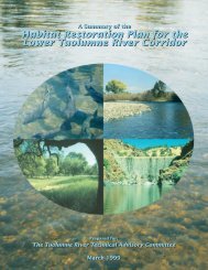
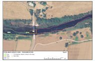
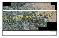
TUOLUMNE RIVER TECHNICAL ADVISORY COMMITTEEHABITAT RESTORATION PLAN FOR THE LOWER TUOLUMNE RIVER CORRIDORCHAPTER 4Conceptual designs were developed for thefollowing restoration projects, <strong>and</strong> summaries ofthe project background, objectives, projectdescriptions, <strong>and</strong> estimated costs are providedbelow:1. Special Run Pool 5 (RM 32.9 to 33.4)2. Special Run Pool 6 (RM 30.2 to 30.9)3. Special Run Pool 9 (RM 25.6 to 25.9)4. Special Run Pool 10 (RM 25.2 to 25.6)5. Gravel Mining Reach Phase I (RM 37.7 to40.3)6. Gravel Mining Reach Phase II (RM 36.6 to37.7)7. Gravel Mining Reach Phase III (RM 35.2 to36.6)8. Gravel Mining Reach Phase IV (RM 34.3 to35.2)9. Sediment Management <strong>and</strong> ImplementationPlan10. Gasburg Creek Sedimentation Basin (RM50.4)11. Dredger Tailing Reach Phase I (RM 45.4 to46.5)12. Dredger Tailing Reach Phase II (RM 43.8 to45.4)13. Dredger Tailing Reach Phase III (RM 42.2 to43.8)14. Basso Spawning Reach Floodplain Restoration(RM 47.6 to 50.5)Several projects that were not included in the listof 14 channel restoration projects deserveadditional discussion. First, the bedload impedancereach between Riffle 5B (RM 47.9) <strong>and</strong> thelate Riffle 6 (RM 47.0) presently preventssediment transport through it, <strong>and</strong> will continueto do so in the future. Gravel introduced as part ofthe sediment management program will becomedeposited here <strong>and</strong> not route downstream toreplenish the dredger tailing reach until thisbedload impedance reach is fixed. Channelrestoration <strong>and</strong>/or gravel additions in the dredgertailing reach will restore a large source of gravelfor downstream movement, but over the longtermwill be depleted until this impedance reachis filled. Any property in the dredger tailing reachthat becomes available for fee title purchase orconservation easement should be pursued. Thisreach has substantial salmon <strong>and</strong> riparianproduction presently, <strong>and</strong> there is considerablepotential to improve conditions in this reach.<strong>River</strong> front properties <strong>and</strong> those containing gravelsources should be prioritized for preservation <strong>and</strong>restoration or material sources, respectively.The remaining two projects are SRP 7 (RM 26.0 to27.8) <strong>and</strong> SRP 8 (RM 27.9 to 29.5), which areextremely large remnant instream aggregateextraction pits. The cost to restore these pits islarge (over $5 million each). Restoration of twosimilar sites (SRP 9 <strong>and</strong> 10) are underway, <strong>and</strong>we recommend that their effectiveness be evaluatedbefore proceeding with additional pit fillingprojects in the future to determine their costeffectiveness.These three projects should befurther developed in the near future within anexp<strong>and</strong>ed list of projects.An additional three projects that are currentlybeing developed also warrant discussion. The“Grayson <strong>River</strong> Ranch Project” is a 140 acrefloodplain parcel on the south bank of the<strong>Tuolumne</strong> <strong>River</strong> between river miles 5 <strong>and</strong> 6. Theproperty owners applied for <strong>and</strong> received a“perpetual conservation easement” for theirproperty in response to the 1997 flood <strong>and</strong>frequent past flooding. The USDA NaturalResources Conservation <strong>Service</strong> administerseasement agreements in cooperation with the EastStanislaus County Resource ConservationDistrict, linking with various local, state, federal,<strong>and</strong> non-profit partners for funding <strong>and</strong> restorationcoordination.In the upper river, the “Bobcat Flat Project”involves the potential acquisition of a 280 acreparcel. The project involves the fee acquisition ofa large floodplain with two miles of river frontagein the dredger tailing reach. It has significantpotential for enhanced natural floodplain function.The proposal was submitted by the Friendsof the <strong>Tuolumne</strong>, <strong>and</strong> funding for the purchase<strong>and</strong> restoration has been approved by CALFED.Finally, the City of Modesto has begun development<strong>and</strong> implementation of the “<strong>Tuolumne</strong> <strong>River</strong>Regional Parkway”, centered in the City ofModesto. This project includes revision of theJoint Powers Authority General Plan, developmentof the Gateway Parcel located downtown Modestonear the Ninth St. Bridge, <strong>and</strong> potentially extensiverestoration of riparian zones.158