Tuolumne River Report - U.S. Fish and Wildlife Service
Tuolumne River Report - U.S. Fish and Wildlife Service
Tuolumne River Report - U.S. Fish and Wildlife Service

Create successful ePaper yourself
Turn your PDF publications into a flip-book with our unique Google optimized e-Paper software.
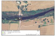
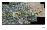
GEOMORPHIC AND RIPARIAN INVESTIGATIONSeliminated at a certain location. The topsoil dikesthrough the rest of the reach continue to fail <strong>and</strong>contribute fine sediment to the channel, butrestoration of a wider floodway throughout thisreach will eventually replace these dikes withfloodplains. The other significant source of finesediment is infrequent failure of dikes that isolatefine sediment settling ponds at gravel extractionsites. Failure of dikes separating these settlingponds from the bankfull channel results in largevolumes of fine sediment input into the river.Additional fine sediment is introduced by the dikefailure itself. This occurred at several locationsduring the 1997 flood <strong>and</strong> at least one location in1998. While much of this sediment is probablywashload, there is probably a significant volumeof s<strong>and</strong>-sized fine sediment delivered to the<strong>Tuolumne</strong> <strong>River</strong>. The floodway restoration projectthrough the gravel mining reach will greatlyreduce future fine sediment inputs from thesesites.3.1.4.2. SummaryOf all the gullies <strong>and</strong> tributaries investigated,Gasburg Creek, Lower Dominici Creek, <strong>and</strong>Peaslee Creek are the primary s<strong>and</strong> contributors.Much of the s<strong>and</strong> originating from Gasburg Creekhas historically resulted from sheet runoff fromthe s<strong>and</strong> extraction operation immediately northof the Old La Grange Bridge. Gasburg Creek hasthe highest potential to negatively impact salmonhabitat because it delivers s<strong>and</strong> at the upstreamend of the most important reach for salmonproduction. Remediation for Gasburg Creek issimple; a sedimentation pond near its mouthwould prevent nearly all harmful fine sediments(between 0.1 mm <strong>and</strong> 8 mm) from entering the<strong>Tuolumne</strong> <strong>River</strong> (see Sediment Management Plansummary in Chapter 4). Lower Dominici Creek<strong>and</strong> Peaslee Creek enter the <strong>Tuolumne</strong> <strong>River</strong>through incised channels; there is little spaceavailable near their mouths to construct a sedimentationpond. There may be some opportunityto construct a head control structure on LowerDominici Creek immediately upstream of theMID canal, but no site reconnaissance has beenconducted. Improved l<strong>and</strong> use practices, particularlyalong tributary watercourses, could alsoreduce fine sediment inputs. We recommend spotHelley-Smith bedload measurements with a 3-inch sampler during storm runoff events to betterevaluate s<strong>and</strong> contribution from Lower DominiciCreek before proceeding with remediation.Constructing floodplains <strong>and</strong> increasing themagnitude <strong>and</strong> variability of high flow releaseswill help mitigate the negative impact of finesediment delivery from the watershed by encouragingnatural deposition on floodplain surfaces.During high flow releases, sediment finer than 1mm is typically transported in suspension in themainstem <strong>Tuolumne</strong> <strong>River</strong>; fluvial access tofloodplain surfaces will cause these sediments todeposit on the floodplains, reducing the proportiondepositing in the mainstem channel.3.1.5. M.J. Ruddy 4-Pumps restorationproject evaluationBetween 1992 <strong>and</strong> 1993, a restoration <strong>and</strong>mitigation project immediately upstream of theSanta Fe Aggregates (formerly M.J. Ruddy) plantsite (RM 36.7 to 37.6) was implemented toreconstruct nearly one mile of channel. Theunique feature of this project was that it attemptedto reconstruct an alluvial channel sized to thepost-dam flow regime, with bankfull channel,floodplains, <strong>and</strong> terraces. Past restoration activitiesprimarily focused on modifying the activechannel (mostly riffle rehabilitation) <strong>and</strong> plantingriparian vegetation. In the summer of 1991, theM.J. Ruddy Mitigation Project reconstructedsouth bank dikes to increase floodway capacity to11,000 cfs from RM 36.7 to 37.0, <strong>and</strong> to providefloodplain <strong>and</strong> terrace surfaces through this reach.In the summer of 1993, the San Joaquin Districtof the California Department of Water Resources(DWR) implemented the M.J. Ruddy 4-PumpsChannel Restoration Project. This project constructeda new bankfull channel geometry <strong>and</strong>planform from RM 36.7 to 37.6, <strong>and</strong> constructedfloodplain <strong>and</strong> terrace surfaces from RM 37.0 to37.6. The most significant component of theproject was moving the bankfull channel approximately200 feet north from RM 37.3 to RM 37.6to reduce erosion into an orchard, <strong>and</strong> redistributingsteep drops in channel elevation back into lowgradient pool-riffle sequences to improve chinooksalmon habitat.From the end of construction in 1993 to thebeginning of 1997, several high flow eventsoccurred, ranging from 5,000 cfs to 9,000 cfs,which were large enough to cause the channel toadjust its bed <strong>and</strong> bank morphology. These highflows provided a unique opportunity to evaluatehow a reconstructed, appropriately-scaled channelwould respond to high flow events. Would theCHAPTER 391