Climate Change Vulnerability Assessment and Adaptation Planning ...
Climate Change Vulnerability Assessment and Adaptation Planning ...
Climate Change Vulnerability Assessment and Adaptation Planning ...
- No tags were found...

You also want an ePaper? Increase the reach of your titles
YUMPU automatically turns print PDFs into web optimized ePapers that Google loves.
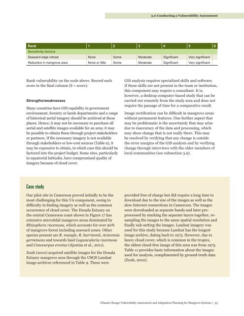
3.0 Conducting a <strong>Vulnerability</strong> <strong>Assessment</strong>Rank 1 2 3 4 5 SSensitivity factorsSeaward edge retreat None Some Moderate Significant Very significantReduction in mangrove area None or little Some Moderate Significant Very significantRank vulnerability on the scale above. Record eachscore in the final column (S = score).Strengths/weaknessesMany countries have GIS capability in governmentenvironment, forestry or l<strong>and</strong>s departments <strong>and</strong> a rangeof historical aerial imagery should be archived at theseplaces. Hence, it may not be necessary to purchase allaerial <strong>and</strong> satellite images available for an area; it maybe possible to obtain these through project stakeholdersor partners. If the necessary imagery is not availablethrough stakeholders or low-cost sources (Table 9), itmay be expensive to obtain, in which case this should befactored into the project budget. Some sites, particularlyin equatorial latitudes, have compromised quality ofimagery because of cloud cover.GIS analysis requires specialized skills <strong>and</strong> software.If these skills are not present in the team or institution,this component may require a consultant. It is,however, a desktop computer-based study that can becarried out remotely from the study area <strong>and</strong> does notrequire the passage of time for a comparative result.Image rectification can be difficult in mangrove areaswithout permanent features. One further aspect thatmay be problematic is the uncertainly that may arisedue to inaccuracy of the data <strong>and</strong> processing, whichmay show change that is not really there. This maybe resolved by verifying that any change is outsidethe error margins of the GIS analysis <strong>and</strong> by verifyingchange through interviews with the older members oflocal communities (see subsection 3.9).Case studyOur pilot site in Cameroon proved initially to be themost challenging for this VA component, owing todifficulty in finding imagery as well as the commonoccurrence of cloud cover. The Douala Estuary onthe central Cameroon coast shown in Figure 17 hasextensive microtidal mangrove areas dominated byRhizophora racemosa, which accounts for over 90%of mangrove forest including seaward zones. Otherspecies present are R. mangle, R. harrisonii, Avicenniagerminans <strong>and</strong> towards l<strong>and</strong> Laguncularia racemosa<strong>and</strong> Conocarpus erectus (Ajonina et al., 2011).Zouh (2010) acquired satellite images for the DoualaEstuary mangrove area through the USGS L<strong>and</strong>satimage archives referenced in Table 9. These wereprovided free of charge but did require a long time todownload due to the size of the images as well as theslow Internet connections in Cameroon. The imageswere downloaded as separate b<strong>and</strong>s <strong>and</strong> later preprocessedby stacking the separate layers together, resamplingthe images to the same spatial resolution <strong>and</strong>finally sub-setting the images. L<strong>and</strong>sat imagery wasused for this study because L<strong>and</strong>sat has the longestimage archive, dating back to 1973. However, due toheavy cloud cover, which is common in the tropics,the oldest cloud-free image of this area was from 1975.Table 11 provides basic information about the imagesused for analysis, complimented by ground-truth data(Zouh, 2010).<strong>Climate</strong> <strong>Change</strong> <strong>Vulnerability</strong> <strong>Assessment</strong> <strong>and</strong> <strong>Adaptation</strong> <strong>Planning</strong> for Mangrove Systems | 33