Climate Change Vulnerability Assessment and Adaptation Planning ...
Climate Change Vulnerability Assessment and Adaptation Planning ...
Climate Change Vulnerability Assessment and Adaptation Planning ...
- No tags were found...

Create successful ePaper yourself
Turn your PDF publications into a flip-book with our unique Google optimized e-Paper software.
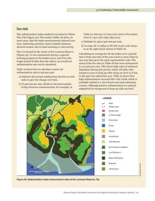
3.0 Conducting a <strong>Vulnerability</strong> <strong>Assessment</strong>Case studyThe sedimentation stakes method was tested in TikinaWai, Fiji (Figure 42). The results (Table 18) show, inmost cases, that the stake measurements reduced overtime, indicating accretion. Some isolated instancesshowed erosion, due to local scouring or crab activity.Site 2 is located in the center of the Lomawai Reserve(Figure 42). It was remeasured during a regionaltraining program in November 2010, <strong>and</strong> from thislonger period of data than the others, an overall netsedimentation rate can be calculated.Table 19 shows how to calculate a mean netsedimentation rate in mm per year:a) Subtract the second reading from the first at eachstake to give the change over time.b) To get mm per day, divide by the total numberof days between measurements; for example, inTable 19, between 27 June 2007 <strong>and</strong> 10 November2010 is 1,231 (187+365+365+314).c) Multiply by 365 to get mm per year.d) Average all 10 stakes at the site to get a site mean,as in the right-h<strong>and</strong> column of Table 18.Calculating an average for all site stakes over a periodthat is from one time of the year (such as June/July) toone year later gives the most representative rate. Themean of the five sites in Table 18 that were remeasuredis 14.9 mm per year. This shows high rates of sedimentdeposition during this period, which will allow thismangrove area to keep up with rising sea level as it hasin the past (see subsection 3.5). Table 19 shows thathigh sedimentation occurred after July 2008, which isprobably related to a river flood event <strong>and</strong> catchmenterosion. Although positive sedimentation is a naturaladaptation for mangroves to keep up with sea levelLEGENDRoadRailway trackSalt flatRhizophoraboundarySample sitesLomawai villageLW3River/CreekRhizophora/BruguieraboundaryOceanSalt panLow tide flatsLW2Cultivated l<strong>and</strong>Non-mangrove vegetationLow RhizophoraMature RhizophoraN500 metresRhizophoraseawardedgeLW1BruguieraLittoral forestBy Michael HelmanFigure 42. Sedimentation stake measurement sites at the Lomawai Reserve, Fiji.<strong>Climate</strong> <strong>Change</strong> <strong>Vulnerability</strong> <strong>Assessment</strong> <strong>and</strong> <strong>Adaptation</strong> <strong>Planning</strong> for Mangrove Systems | 65