Minnegang Creek Flood Study Report - Wollongong City Council
Minnegang Creek Flood Study Report - Wollongong City Council
Minnegang Creek Flood Study Report - Wollongong City Council
- No tags were found...
Create successful ePaper yourself
Turn your PDF publications into a flip-book with our unique Google optimized e-Paper software.
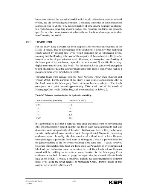
interaction between the numerical model, which would otherwise operate as a closedsystem, and the surrounding environment. Continuing simulation of these interactionscan be achieved in MIKE 11 by the specification of time-varying boundary conditions.In a hydrodynamic modelling situation such as this, boundary conditions are generallyspecified as either water levels to simulate tailwater levels, or discharges to simulaterunoff entering the model.5.6.1 Tailwater levelsFor this study, Lake Illawarra has been adopted as the downstream boundary of theMIKE 11 model. Due to the steepness of the catchment, it is unlikely that backwatereffects caused by elevated lake levels would propagate far up <strong>Minnegang</strong> <strong>Creek</strong>,meaning that the flooding behaviour of the majority of the catchment is likely to beinsensitive to the adopted tailwater level. However, it is recognised that flooding ofthe lower part of the catchment, especially the area around Northcliffe Drive, maydisplay some sensitivity to lake levels. For this reason, it was considered appropriateto look at a range of possible tailwater levels rather than adopt a single value, such as amean high water level, for all design events.Tailwater levels were derived from the Lake Illawarra <strong>Flood</strong> <strong>Study</strong> (Lawson andTreloar, 2000). For the purposes of this study, a lake level of corresponding AEP tothe flood event in the <strong>Minnegang</strong> <strong>Creek</strong> catchment has been adopted. The levelscorrespond to a point located approximately 750m south east of the mouth of<strong>Minnegang</strong> <strong>Creek</strong> within Griffins Bay, and are summarised in Table 5-3.Table 5-3 Tailwater levels adopted for hydraulic modellingAnnual exceedence probabilityLake level (m AHD)20% 1.405% 1.812% 2.031% 2.30PMF 3.24It is appropriate to note that a particular lake level and flood event of correspondingAEP are not necessarily related, and that the design event that contributed to each wasdetermined quite independently of the other. Furthermore, there is likely to be somevariation in the critical storm durations due to the significant difference in contributingcatchment areas. In reality, the determination of a flood level in Lake Illawarracorresponding to a particular flood event in <strong>Minnegang</strong> <strong>Creek</strong> is a problem ruled bythe joint probability of the two events occurring at the same time. It could, however,be argued that matching lake level and flood event AEPs leads to an overestimation oflake level (and is therefore conservative) since the peak flood levels in Lake Illawarrawould still be building as the critical storm duration for the <strong>Minnegang</strong> <strong>Creek</strong>catchment is reached. In order to gauge the impact that the adopted tailwater levelshave on the MIKE 11 results, a sensitivity analysis has been undertaken to compareflood levels along the lower reaches of <strong>Minnegang</strong> <strong>Creek</strong>. Further details of thisanalysis are presented in Section 5.9.SV8507-D0-001 Rev 2 5-2218/10/02


