Minnegang Creek Flood Study Report - Wollongong City Council
Minnegang Creek Flood Study Report - Wollongong City Council
Minnegang Creek Flood Study Report - Wollongong City Council
- No tags were found...
You also want an ePaper? Increase the reach of your titles
YUMPU automatically turns print PDFs into web optimized ePapers that Google loves.
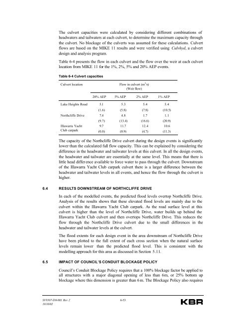
The culvert capacities were calculated by considering different combinations ofheadwaters and tailwaters at each culvert, to determine the maximum capacity throughthe culvert. No blockage of the culverts was assumed for these calculations. Culvertflows are based on the MIKE 11 results and were verified using Culvhyd, a culvertdesign and analysis program.Table 6-4 presents the flow in each culvert and the flow over the weir at each culvertlocation from MIKE 11 for the 1%, 2%, 5% and 20% AEP events.Table 6-4 Culvert capacitiesCulvert locationFlow in culvert (m 3 /s)(Weir flow)20% AEP 5% AEP 2% AEP 1% AEPLake Heights Road 5.15.35.45.4(1.6)(5.8)(7.8)(10.5)Northcliffe Drive 7.44.81.71.1Illawarra YachtClub carpark(9.7)9.7(0.0)(13.4)11.7(0.9)(16.6)12.4(4.7)(20.9)10.6(11.3)The capacity of the Northcliffe Drive culvert during the design events is significantlylower than the calculated full flow capacity. This can be explained by considering thedifference in the headwater and tailwater levels at this culvert. In all the design events,the headwater and tailwater are essentially at the same level. This means that there islittle head differ ence available to force water to pass through the culvert. Downstreamof the Illawarra Yacht Club carpark culvert there is a larger difference between theheadwater and tailwater levels in all events, and hence the flow through the culvert ishigher.6.4 RESULTS DOWNSTREAM OF NORTHCLIFFE DRIVEIn each of the modelled events, the predicted flood levels overtop Northcliffe Drive.Analysis of the results shows that these elevated flood levels are mainly due to theculvert within the Illawarra Yacht Club carpark. As the road surface level at thisculvert is higher than the level of Northcliffe Drive, water builds up behind theIllawarra Yacht Club culvert and then overtops Northcliffe Drive. This reduces theflow through the Northcliffe Drive culvert due to the small differences in theheadwater and tailwater levels at the culvert.The flood extents for each design event in the area downstream of Northcliffe Drivehave been plotted to the full extent of each cross section when the natural surfacelevels remain lower than the predicted flood level. This is consistent with themodelling approach for this area as discussed in Section 5.11.6.5 IMPACT OF COUNCIL’S CONDUIT BLOCKAGE POLICY<strong>Council</strong>’s Conduit Blockage Policy requires that a 100% blockage factor be applied toall structures with a major diagonal opening of less than 6 m, or 25% bottom upblockage where this dimension is greater than 6 m. The Blockage Policy also requiresSV8507-D0-001 Rev 2 6-5318/10/02


