- Page 1 and 2: Proof Copy ([5e/3] reformatted to P
- Page 3 and 4: 3G-83 G. Evidence certifying that M
- Page 5 and 6: 5Notes:(1) Before this monograph wa
- Page 7 and 8: A-2or disk"). The information which
- Page 9 and 10: A-4immune deficiency, thus it is qu
- Page 11 and 12: A-6edition, 1986) even tries to arg
- Page 13 and 14: A-8changes have no connection with
- Page 15 and 16: A-10Fig. A2. The curved slope in th
- Page 17 and 18: B-12inspired me to suspect that hum
- Page 19 and 20: B-14Earth by evil UFOnauts God trie
- Page 21 and 22: C-16#10. The spread, radiating from
- Page 23 and 24: C-18"Te Ura-a-Te Raki-Tamau", which
- Page 25 and 26: C-20item #2 that follows). Thus, in
- Page 27 and 28: C-22comparative data which reflects
- Page 29 and 30: C-24exploding fires, columns of fir
- Page 31 and 32: C-26banks of the Black Gully Creek,
- Page 33 and 34: C-28meditating, conducting healing
- Page 35 and 36: C-30deaths of people with symptoms
- Page 37 and 38: C-32(1) The Kawakawa volcano erupte
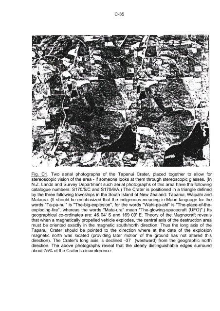
- Page 39: C-34The Tapanui Crater is the centr
- Page 43 and 44: C-38(a)(d)(b)(c)(e)Fig. C4. Example
- Page 45 and 46: C-40Fig. C6. The illustration of si
- Page 47 and 48: C-42Fig. C8. The distribution of in
- Page 49 and 50: C-44Fig. C10. Two photographs of a
- Page 51 and 52: C-46Fig. C12. The location of near-
- Page 53 and 54: C-48Fig. C14. A magnetized metallic
- Page 55 and 56: D-50Chapter D:EVIDENCE THAT THE TAP
- Page 57 and 58: D-52including Mediterranean and Biz
- Page 59 and 60: D-54rapidly released by this explos
- Page 61 and 62: D-56experiments, and many more. Thi
- Page 63 and 64: D-58that people were in medieval ti
- Page 65 and 66: D-60then continually resonates in t
- Page 67 and 68: D-62"tapanui.htm") are to be met, s
- Page 69 and 70: D-64when such abnormalities of the
- Page 71 and 72: E-66Chapter E.HYPOTHESES EXPLAINING
- Page 73 and 74: E-68is directed towards the magneti
- Page 75 and 76: F-70publication of this design and
- Page 77 and 78: F-72can be built, each type taking
- Page 79 and 80: F-74sites an explosive growth of mu
- Page 81 and 82: F-76F4. Explosion sites of the Magn
- Page 83 and 84: F-78- Deficiency of some sensitive
- Page 85 and 86: F-80(a)…(b)…(c)Fig. F2. The des
- Page 87 and 88: F-82Fig. F4. The explanation for a
- Page 89 and 90: G-84The formal proof that "UFOs are
- Page 91 and 92:
G-86civilization(s) sending UFOs mu
- Page 93 and 94:
G-88the close proximity of the Tapa
- Page 95 and 96:
G-90(c)(d)Fig. G1. Two photographs
- Page 97 and 98:
G-92(a)(c)(b)(d)(e)Fig. G3. A spher
- Page 99 and 100:
G-94(a)(b)(c)(d)Fig. G5. Pulsating
- Page 101 and 102:
G-96(a)(b)(c)(d)(e)Fig. G7. Smooth,
- Page 103 and 104:
G-98(a)(b)(c)(d)Fig. G9. Photograph
- Page 105 and 106:
H-100#6. The Tapanui Crater is orie
- Page 107 and 108:
I-102Chapter I:MORAL ACCENTUATION O
- Page 109 and 110:
J-104explosion energy carrier would
- Page 111 and 112:
J-106detonation a number of appropr
- Page 113 and 114:
J-108resembled "china stones" from
- Page 115 and 116:
K-110Chapter K:AROUND 13 500 YEARS-
- Page 117 and 118:
K-112civilisation were prepared for
- Page 119 and 120:
L-114Chapter L:STILL ANOTHER UFO EX
- Page 121 and 122:
L-116Coincidentally, the author had
- Page 123 and 124:
M-118in section D3). This in turn h
- Page 125 and 126:
N-120Chapter N:TWELVE TRUTHS ABOUT
- Page 127 and 128:
N-122only factors which may cause t
- Page 129 and 130:
N-124ones who stand by truth and th
- Page 131 and 132:
O-126Chapter O:ACADEMIC ASPECTS OF
- Page 133 and 134:
O-128Galactic field, thus producing
- Page 135 and 136:
O-130specifically what was wrong wi
- Page 137 and 138:
O-132moral field causes that we acc
- Page 139 and 140:
O-134white glowing balls of playful
- Page 141 and 142:
O-136brought disgrace to that unive
- Page 143 and 144:
O-138the Polish language only, whic
- Page 145 and 146:
O-140occupation of Earth, and then
- Page 147 and 148:
O-142in a few years of time, when t
- Page 149 and 150:
O-144and both these matters were se
- Page 151 and 152:
O-146today. We need to realize this
- Page 153 and 154:
O-148Of course, the above history i
- Page 155 and 156:
O-150two kinds of resource publicat
- Page 157 and 158:
R-152Chapter R:AT THE END OF THIS M
- Page 159 and 160:
R-154forget that such paid scientis
- Page 161 and 162:
S-156Chapter S:REFERENCES COMPLEMEN
- Page 163 and 164:
S-158[7/2] Giordano D. and Pajak J.
- Page 165 and 166:
T-160Magnocraft exploded over New Z
- Page 167 and 168:
Z-162Appendix Z:Directions for gett
- Page 169:
Z-164Fig. Z1. The most educational


![[1/4p]: PDF - Totalizm](https://img.yumpu.com/45003232/1/184x260/1-4p-pdf-totalizm.jpg?quality=85)

![[1/4p]: PDF - Totalizm](https://img.yumpu.com/39351336/1/184x260/1-4p-pdf-totalizm.jpg?quality=85)