

The Soils of Elgin County - Agriculture and Agri-Food Canada
The Soils of Elgin County - Agriculture and Agri-Food Canada
The Soils of Elgin County - Agriculture and Agri-Food Canada
- No tags were found...

You also want an ePaper? Increase the reach of your titles
YUMPU automatically turns print PDFs into web optimized ePapers that Google loves.
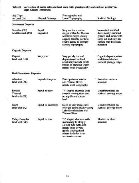
Table 2.Correlation <strong>of</strong> major soils <strong>and</strong> l<strong>and</strong> units with physiography <strong>and</strong> surficial geology in<strong>Elgin</strong> <strong>County</strong> (continued)Soil Typeor L<strong>and</strong> UnitNatural DrainagePhysiography <strong>and</strong>Usual TopographySurficial GeologyIce-contact DepositsShedden (SH)Middlemarch (MI)RapidImperfectStagnant ice moraineridges within St . ThomasMoraine; ridges usuallyaligned roughly north tosouth; gently to stronglysloping topographyIce-contact stratifieddrift; mostly stratifiedgravels <strong>and</strong> s<strong>and</strong>s withsome silt <strong>and</strong> clay till ;surface may be eolianmodifiedOrganic DepositsOrganicl<strong>and</strong> unit (OR)Very poorVery poorly draineddepressional wetl<strong>and</strong>areas; may include smallbodies <strong>of</strong> st<strong>and</strong>ing water;nearly level topographyOrganic deposits, <strong>of</strong>tenundifferentiated onsurficial geology mapsUndifferentiated DepositsAlluvium .l<strong>and</strong> unit (AL)Imperfect to poorFlood plains <strong>of</strong> creeks<strong>and</strong> Thames River;nearly level topographyRecent or modernalluviumErodedChannell<strong>and</strong> unit (ER)Rapid to poor"V" shaped channels withsteeply sloping sides <strong>and</strong>no significant bottoml<strong>and</strong>Undifferentiated onsurficial geology mapsScarpl<strong>and</strong> unit (SC)Rapid to imperfectSteep to very steep cliffsor bluffs found mainly alongLake Erie shoreline <strong>and</strong>Thames RiverUndifferentiated onsurficial geology mapsValley Complexl<strong>and</strong> unit (VC)Rapid to poor"U" shaped channels withmoderately to steeplysloping side walls <strong>and</strong>nearly level to verygently sloping floodplains ; includes river<strong>and</strong> creek coursesModem or olderalluvium


