Uptown Transportation Study - OKI
Uptown Transportation Study - OKI
Uptown Transportation Study - OKI

Create successful ePaper yourself
Turn your PDF publications into a flip-book with our unique Google optimized e-Paper software.
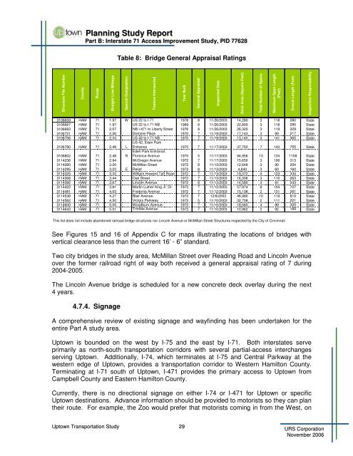
Planning <strong>Study</strong> ReportPart B: Interstate 71 Access Improvement <strong>Study</strong>, PID 77628Table 8: Bridge General Appraisal RatingsStructure File NumberCountyRouteStraight Line MileageSpecial DesignationFeature IntersectedYear BuiltGeneral AppraisalInspected DateDeck Area (Square Feet)Total Number of SpansMaximum Span Length(Feet)Overal Length (Feet)Inspection Responsibility3106659 HAM 71 1.97 W US 22 to I-71 1976 8 11/26/2003 14,280 3 118 280 State3106667 HAM 71 1.97 US 22 to I-71 NB 1969 8 11/26/2003 22,800 3 118 285 State3106683 HAM 71 2.07 NB I-471 to Liberty Street 1976 8 11/26/2003 26,320 3 119 329 State3106721 HAM 71 2.26 Elsinore Place 1970 7 11/19/2003 17,143 3 89 217 State3106756 HAM 71 2.33 US 42 to I-71 NB 1970 7 11/19/2003 13,140 3 141 365 State3106780 HAM 71 2.48 LUS 42; Eden ParkEntrance 1970 7 11/17/2003 37,750 7 143 755 State3106802 HAM 71 2.48 REden Park Entrance;Florence Avenue 1970 5 11/17/2003 94,956 13 134 1158 State3114236 HAM 71 2.94 McGregor Avenue 1972 7 11/17/2003 15,650 3 106 313 State3114260 HAM 71 3.20 McMillan Street 1972 8 11/13/2003 12,648 3 90 204 State3114295 HAM 71 3.22 E Relief 1972 8 11/13/2003 4,640 3 60 160 State3114325 HAM 71 3.32 William Howard Taft Road 1972 7 11/13/2003 19,372 4 123 334 State3114368 HAM 71 3.44 Oak Street 1972 7 11/13/2003 16,306 3 110 263 State3114392 HAM 71 3.67 Lincoln Avenue 1972 8 11/13/2003 14,580 3 91 243 State3114422 HAM 71 3.81 Martin Luther King Jr. Dr. 1972 7 11/12/2003 57,974 8 104 707 State3114481 HAM 71 4.03 Fredonia Avenue 1972 7 11/12/2003 15,138 2 131 261 State3114538 HAM 71 4.27 Blair Avenue 1972 7 12/8/2003 46,980 10 119 810 State3114562 HAM 71 4.50 Victory Parkway 1972 5 11/10/2003 32,708 2 111 221 State3114600 HAM 71 5.05 Woodburn Avenue 1972 7 11/10/2003 18,560 4 99 320 State3114643 HAM 71 5.51 Trimble Avenue 1972 7 11/10/2003 10,962 2 92 189 StateThis list does not include abandoned railroad bridge structures nor Lincoln Avenue or McMillan Street Structures inspected by the City of CincinnatiSee Figures 15 and 16 of Appendix C for maps illustrating the locations of bridges withvertical clearance less than the current 16’ - 6” standard.Two city bridges in the study area, McMillan Street over Reading Road and Lincoln Avenueover the former railroad right of way both received a general appraisal rating of 7 during2004-2005.The Lincoln Avenue bridge is scheduled for a new concrete deck overlay during the next4 years.4.7.4. SignageA comprehensive review of existing signage and wayfinding has been undertaken for theentire Part A study area.<strong>Uptown</strong> is bounded on the west by I-75 and the east by I-71. Both interstates serveprimarily as north-south transportation corridors with several partial-access interchangesserving <strong>Uptown</strong>. Additionally, I-74, which terminates at I-75 and Central Parkway at thewestern edge of <strong>Uptown</strong>, provides a transportation corridor to Western Hamilton County.Terminating at I-71 south of <strong>Uptown</strong>, I-471 provides the primary access to <strong>Uptown</strong> fromCampbell County and Eastern Hamilton County.Currently, there is no directional signage on either I-74 or I-471 for <strong>Uptown</strong> or specific<strong>Uptown</strong> destinations. Advance information should be provided to motorists so they can plantheir route. For example, the Zoo would prefer that motorists coming in from the West, on<strong>Uptown</strong> <strong>Transportation</strong> <strong>Study</strong> 29URS CorporationNovember 2006