Uptown Transportation Study - OKI
Uptown Transportation Study - OKI
Uptown Transportation Study - OKI
Create successful ePaper yourself
Turn your PDF publications into a flip-book with our unique Google optimized e-Paper software.
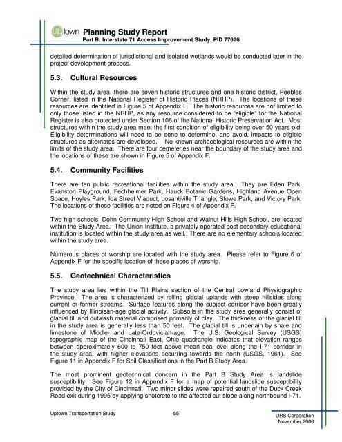
Planning <strong>Study</strong> ReportPart B: Interstate 71 Access Improvement <strong>Study</strong>, PID 77628detailed determination of jurisdictional and isolated wetlands would be conducted later in theproject development process.5.3. Cultural ResourcesWithin the study area, there are seven historic structures and one historic district, PeeblesCorner, listed in the National Register of Historic Places (NRHP). The locations of theseresources are identified in Figure 5 of Appendix F. The historic resources are not limited toonly those listed in the NRHP, as any resource considered to be “eligible” for the NationalRegister is also protected under Section 106 of the National Historic Preservation Act. Moststructures within the study area meet the first condition of eligibility being over 50 years old.Eligibility determinations will need to be done to determine, and avoid, impacts to eligiblestructures as alternates are developed. No known archaeological resources are within thelimits of the study area. There are four cemeteries near the boundary of the study area andthe locations of these are shown in Figure 5 of Appendix F.5.4. Community FacilitiesThere are ten public recreational facilities within the study area. They are Eden Park,Evanston Playground, Fechheimer Park, Hauck Botanic Gardens, Highland Avenue OpenSpace, Hoyles Park, Ida Street Viaduct, Losantiville Triangle, Stowe Park, and Victory Park.The locations of these facilities are noted on Figure 4 of Appendix F.Two high schools, Dohn Community High School and Walnut Hills High School, are locatedwithin the <strong>Study</strong> Area. The Union Institute, a privately operated post-secondary educationalinstitution is located within the study area as well. There are no elementary schools locatedwithin the study area.Numerous places of worship are located with the study area. Please refer to Figure 6 ofAppendix F for the specific location of these places of worship.5.5. Geotechnical CharacteristicsThe study area lies within the Till Plains section of the Central Lowland PhysiographicProvince. The area is characterized by rolling glacial uplands with steep hillsides alongcurrent or former streams. Surface features along the subject corridor have been greatlyinfluenced by Illinoisan-age glacial activity. Subsoils in the study area generally consist ofglacial till and outwash material comprised primarily of clay. The thickness of the glacial tillin the study area is generally less than 50 feet. The glacial till is underlain by shale andlimestone of Middle- and Late-Ordovician-age. The U.S. Geological Survey (USGS)topographic map of the Cincinnati East, Ohio quadrangle indicates that elevation rangesbetween approximately 600 to 750 feet above mean sea level along the I-71 corridor inthe study area, with higher elevations occurring towards the north (USGS, 1961). SeeFigure 11 in Appendix F for Soil Classifications in the Part B <strong>Study</strong> Area.The most prominent geotechnical concern in the Part B <strong>Study</strong> Area is landslidesusceptibility. See Figure 12 in Appendix F for a map of potential landslide susceptibilityprovided by the City of Cincinnati. Two minor slides were repaired south of the Duck CreekRoad exit during 1995 by applying shotcrete to the affected cut slope along northbound I-71.<strong>Uptown</strong> <strong>Transportation</strong> <strong>Study</strong> 55URS CorporationNovember 2006


