Introductory Exercises for GIS Using ArcMap & ArcCatalog
Introductory Exercises for GIS Using ArcMap & ArcCatalog
Introductory Exercises for GIS Using ArcMap & ArcCatalog

You also want an ePaper? Increase the reach of your titles
YUMPU automatically turns print PDFs into web optimized ePapers that Google loves.
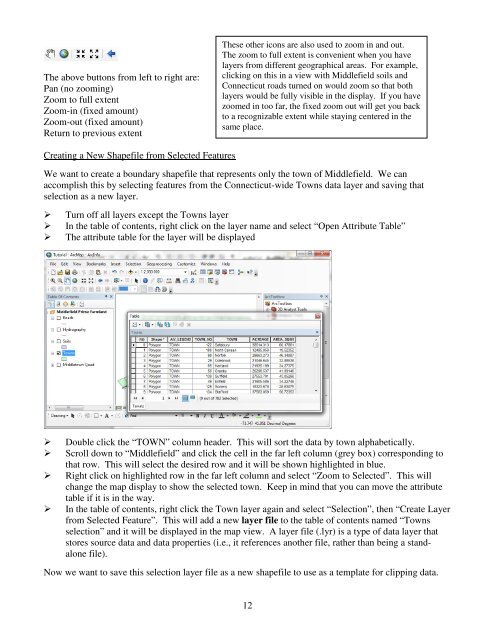
The above buttons from left to right are:Pan (no zooming)Zoom to full extentZoom-in (fixed amount)Zoom-out (fixed amount)Return to previous extentThese other icons are also used to zoom in and out.The zoom to full extent is convenient when you havelayers from different geographical areas. For example,clicking on this in a view with Middlefield soils andConnecticut roads turned on would zoom so that bothlayers would be fully visible in the display. If you havezoomed in too far, the fixed zoom out will get you backto a recognizable extent while staying centered in thesame place.Creating a New Shapefile from Selected FeaturesWe want to create a boundary shapefile that represents only the town of Middlefield. We canaccomplish this by selecting features from the Connecticut-wide Towns data layer and saving thatselection as a new layer.Turn off all layers except the Towns layerIn the table of contents, right click on the layer name and select “Open Attribute Table”The attribute table <strong>for</strong> the layer will be displayedDouble click the “TOWN” column header. This will sort the data by town alphabetically.Scroll down to “Middlefield” and click the cell in the far left column (grey box) corresponding tothat row. This will select the desired row and it will be shown highlighted in blue.Right click on highlighted row in the far left column and select “Zoom to Selected”. This willchange the map display to show the selected town. Keep in mind that you can move the attributetable if it is in the way.In the table of contents, right click the Town layer again and select “Selection”, then “Create Layerfrom Selected Feature”. This will add a new layer file to the table of contents named “Townsselection” and it will be displayed in the map view. A layer file (.lyr) is a type of data layer thatstores source data and data properties (i.e., it references another file, rather than being a standalonefile).Now we want to save this selection layer file as a new shapefile to use as a template <strong>for</strong> clipping data.12