Introductory Exercises for GIS Using ArcMap & ArcCatalog
Introductory Exercises for GIS Using ArcMap & ArcCatalog
Introductory Exercises for GIS Using ArcMap & ArcCatalog

Create successful ePaper yourself
Turn your PDF publications into a flip-book with our unique Google optimized e-Paper software.
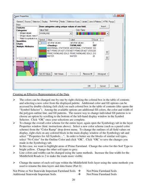
Creating an Effective Representation of the DataThe colors can be changed one-by-one by right clicking the colored box in the table of contentsand selecting a new color from the displayed palette. Additional color and fill options can beaccessed by double clicking (left click) on each colored box in the table of contents (this opens the“Symbol Selector”). Among the available options are additional fill colors, the color and width ofthe polygon outline line, and fill patterns. The easiest way to change individual fill patterns is tochoose an option by scrolling to the bottom of the left-hand display window in the SymbolSelector. Click “OK” once your selections are complete.To change the overall color scheme <strong>for</strong> the entire layer, again open the Symbology tab in the layerProperties window (hint: instructions above). Select a new color scheme (such as a pastel colorscheme) from the “Color Ramp” drop down menu. To change the outlines of all field values ondisplay, right click on any colored block in the main display window of the Symbology tab andselect “”Properties <strong>for</strong> All Symbols…”. In order to better see the blocks of similar soil types,select “No Color” <strong>for</strong> the Outline Color and click “OK”. Click “OK” to save the changes youmade in the Symbology tab.In this case, we want to highlight areas of Prime Farmland. Change the color <strong>for</strong> this Soil Type tobright yellow. Change the other soil types to grey.Line colors and widths can be changed using the same methods. Increase the line width <strong>for</strong> theMiddlefield Roads to 2 to make the roads more visible.Change the names of each soil type within the Middlefield Soils layer using the same methods youused to rename the data layers and data frame (Part I):Not Prime or Not Statewide Important Farmland Soils Not Prime Farmland SoilsAdditional Statewide Important Soils Not Prime Farmland Soils20