Introductory Exercises for GIS Using ArcMap & ArcCatalog
Introductory Exercises for GIS Using ArcMap & ArcCatalog
Introductory Exercises for GIS Using ArcMap & ArcCatalog

You also want an ePaper? Increase the reach of your titles
YUMPU automatically turns print PDFs into web optimized ePapers that Google loves.
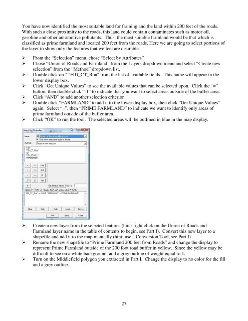
You have now identified the most suitable land <strong>for</strong> farming and the land within 200 feet of the roads.With such a close proximity to the roads, this land could contain contaminates such as motor oil,gasoline and other automotive pollutants. Thus, the most suitable farmland would be that which isclassified as prime farmland and located 200 feet from the roads. Here we are going to select portions ofthe layer to show only the features that we feel are desirable. From the “Selection” menu, chose “Select by Attributes” Chose “Union of Roads and Farmland” from the Layers dropdown menu and select “Create newselection” from the “Method” dropdown list. Double click on " "FID_CT_Roa" from the list of available fields. This name will appear in thelower display box. Click “Get Unique Values” to see the available values that can be selected upon. Click the “=”button, then double click “-1” to indicate that you want to select areas outside of the buffer area. Click “AND” to add another selection criterion Double click “FARMLAND” to add it to the lower display box, then click “Get Unique Values”again. Select “=”, then “PRIME FARMLAND” to indicate we want to identify only areas ofprime farmland outside of the buffer area. Click “OK” to run the tool. The selected areas will be outlined in blue in the map display.Create a new layer from the selected features (hint: right click on the Union of Roads andFarmland layer name in the table of contents to begin, see Part I). Convert this new layer to ashapefile and add it to the map manually (hint: use a Conversion Tool, see Part I).Rename the new shapefile to “Prime Farmland 200 feet from Roads” and change the display torepresent Prime Farmland outside of the 200 foot road buffer in yellow. Since the yellow may bedifficult to see on a white background, add a grey outline of weight equal to 1.Turn on the Middlefield polygon you extracted in Part I. Change the display to no color <strong>for</strong> the filland a grey outline.27