Introductory Exercises for GIS Using ArcMap & ArcCatalog
Introductory Exercises for GIS Using ArcMap & ArcCatalog
Introductory Exercises for GIS Using ArcMap & ArcCatalog

You also want an ePaper? Increase the reach of your titles
YUMPU automatically turns print PDFs into web optimized ePapers that Google loves.
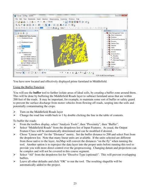
You have now located and effectively displayed prime farmland in Middlefield.<strong>Using</strong> the Buffer FunctionYou will use the buffer tool to further isolate areas of ideal soils, by creating a buffer zone around them.This will be done by buffering the Middlefield Roads layer to subtract farmland areas that are within200 feet of the roads. It may be important, <strong>for</strong> example, to maintain some sort of buffer or safety guardto prevent the surface discharge from motor vehicles from flowing off roads, seeping into the soils andpotentially contaminating the crops.Turn on the Middlefield Roads layerChange the road line width back to 1 by double clicking the line in the table of contents.To buffer the roads: From the toolbox display, select “Analysis Tools”, then “Proximity”, then “Buffer”. Select “Middlefield Roads” from the dropdown list of Input Features. As usual, the OutputFeature Class will be automatically determined and can be modified if desired. Chose “Linear unit” <strong>for</strong> the “Distance” metric. Set the buffer distance to 200 and select Feet fromthe dropdown list. Note that many linear units are available. If the units selected are differentfrom those native to the layer, <strong>ArcMap</strong> will convert the distances “on the fly” when running thetool. Another option is to reproject the data layer into the proper units be<strong>for</strong>e running this tool toprovide you with more direct control over the geoprocessing. Changing datum and projections canbe complex and will not be covered in this course segment. Select “All” from the dropdown list <strong>for</strong> “Dissolve Type (optional)”. This will prevent overlappingbuffers. Leave all other defaults and click “OK” to run the tool. The resulting shapefile will beautomatically added to the project.23