Introductory Exercises for GIS Using ArcMap & ArcCatalog
Introductory Exercises for GIS Using ArcMap & ArcCatalog
Introductory Exercises for GIS Using ArcMap & ArcCatalog

You also want an ePaper? Increase the reach of your titles
YUMPU automatically turns print PDFs into web optimized ePapers that Google loves.
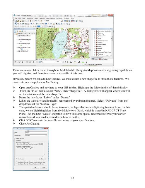
There are several lakes found throughout Middlefield. <strong>Using</strong> <strong>ArcMap</strong>’s on-screen digitizing capabilitiesyou will digitize, and there<strong>for</strong>e create, a shapefile of this lake.However, be<strong>for</strong>e we can add new features, we must create a new shapefile to store those features. Wecan create new shapefiles in <strong>ArcCatalog</strong>.Open <strong>ArcCatalog</strong> and navigate to your <strong>GIS</strong> folder. Highlight the folder in the left-hand display.From the “File” menu, select “New”, then “Shapefile”. A dialog box will appear where you willset the attributes of the new shapefile.Name the new layer “Lakes” under “Name:”Lakes are typically (and logically) represented by polygon features. Select “Polygon” from thedropdown list <strong>for</strong> “Feature Type”The spatial reference should be set to match the layer that we are digitizing features from. In thiscase, we are digitizing lakes from the Middletown Quad, which is stored in NAD 27 CT StatePlane. Set the new “Lakes” shapefile to have this same spatial reference (refer to your earlierinstructions if you need a reminder on how to do this)Click “OK” to create the new file according to your specificationsClose <strong>ArcCatalog</strong>15