Introductory Exercises for GIS Using ArcMap & ArcCatalog
Introductory Exercises for GIS Using ArcMap & ArcCatalog
Introductory Exercises for GIS Using ArcMap & ArcCatalog

You also want an ePaper? Increase the reach of your titles
YUMPU automatically turns print PDFs into web optimized ePapers that Google loves.
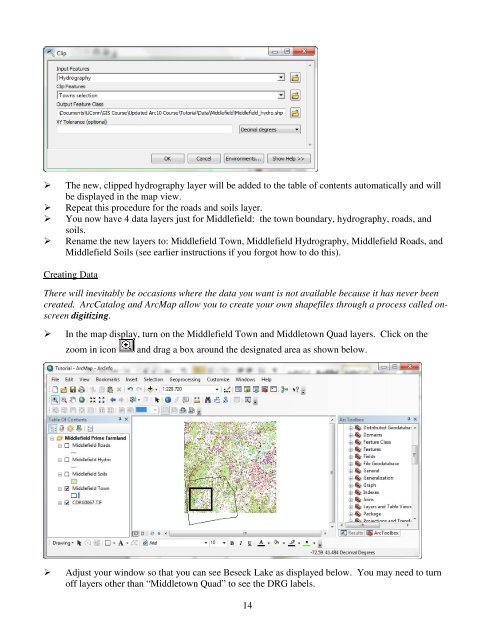
The new, clipped hydrography layer will be added to the table of contents automatically and willbe displayed in the map view.Repeat this procedure <strong>for</strong> the roads and soils layer.You now have 4 data layers just <strong>for</strong> Middlefield: the town boundary, hydrography, roads, andsoils.Rename the new layers to: Middlefield Town, Middlefield Hydrography, Middlefield Roads, andMiddlefield Soils (see earlier instructions if you <strong>for</strong>got how to do this).Creating DataThere will inevitably be occasions where the data you want is not available because it has never beencreated. <strong>ArcCatalog</strong> and <strong>ArcMap</strong> allow you to create your own shapefiles through a process called onscreendigitizing.In the map display, turn on the Middlefield Town and Middletown Quad layers. Click on thezoom in iconand drag a box around the designated area as shown below.Adjust your window so that you can see Beseck Lake as displayed below. You may need to turnoff layers other than “Middletown Quad” to see the DRG labels.14