Introductory Exercises for GIS Using ArcMap & ArcCatalog
Introductory Exercises for GIS Using ArcMap & ArcCatalog
Introductory Exercises for GIS Using ArcMap & ArcCatalog

You also want an ePaper? Increase the reach of your titles
YUMPU automatically turns print PDFs into web optimized ePapers that Google loves.
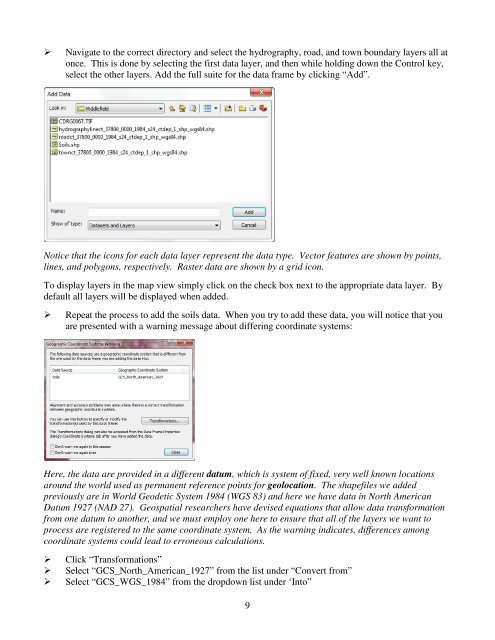
Navigate to the correct directory and select the hydrography, road, and town boundary layers all atonce. This is done by selecting the first data layer, and then while holding down the Control key,select the other layers. Add the full suite <strong>for</strong> the data frame by clicking “Add”.Notice that the icons <strong>for</strong> each data layer represent the data type. Vector features are shown by points,lines, and polygons, respectively. Raster data are shown by a grid icon.To display layers in the map view simply click on the check box next to the appropriate data layer. Bydefault all layers will be displayed when added.Repeat the process to add the soils data. When you try to add these data, you will notice that youare presented with a warning message about differing coordinate systems:Here, the data are provided in a different datum, which is system of fixed, very well known locationsaround the world used as permanent reference points <strong>for</strong> geolocation. The shapefiles we addedpreviously are in World Geodetic System 1984 (WGS 83) and here we have data in North AmericanDatum 1927 (NAD 27). Geospatial researchers have devised equations that allow data trans<strong>for</strong>mationfrom one datum to another, and we must employ one here to ensure that all of the layers we want toprocess are registered to the same coordinate system. As the warning indicates, differences amongcoordinate systems could lead to erroneous calculations.Click “Trans<strong>for</strong>mations”Select “GCS_North_American_1927” from the list under “Convert from”Select “GCS_WGS_1984” from the dropdown list under ‘Into”9