Theoretical and Experimental DNA Computation (Natural ...
Theoretical and Experimental DNA Computation (Natural ...
Theoretical and Experimental DNA Computation (Natural ...

Create successful ePaper yourself
Turn your PDF publications into a flip-book with our unique Google optimized e-Paper software.
34 2 <strong>Theoretical</strong> Computer Science: A Primer<br />
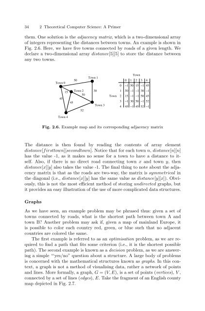
them. One solution is the adjacency matrix, which is a two-dimensional array<br />
of integers representing the distances between towns. An example is shown in<br />
Fig. 2.6. Here, we have five towns connected by roads of a given length. We<br />
declare a two-dimensional array distance[5][5] to store the distance between<br />
any two towns.<br />
Town 0<br />
45<br />
15<br />
Town 4<br />
45<br />
50<br />
Town 2<br />
50<br />
52<br />
Town 1<br />
30<br />
Town 3<br />
Town<br />
0<br />
1<br />
2<br />
3<br />
4<br />
0 1<br />
Town<br />
2 3 4<br />
−1 50 15 −1 45<br />
50 −1 −1 30 −1<br />
15 −1 −1 50 45<br />
−1 30 50 −1 52<br />
45 −1 45 52 −1<br />
Fig. 2.6. Example map <strong>and</strong> its corresponding adjacency matrix<br />
The distance is then found by reading the contents of array element<br />
distance[firsttown][secondtown]. Notice that for each town n, distance[n][n]<br />
has the value -1, as it makes no sense for a town to have a distance to itself.<br />
Also, if there is no direct road connecting town x <strong>and</strong> town y, then<br />
distance[x][y] also takes the value -1. The final thing to note about the adjacency<br />
matrix is that as the roads are two-way, the matrix is symmetrical in<br />
the diagonal (i.e., distance[x][y] has the same value as distance[y][x]). Obviously,<br />
this is not the most efficient method of storing undirected graphs, but<br />
it provides an easy illustration of the use of more complicated data structures.<br />
Graphs<br />
As we have seen, an example problem may be phrased thus: given a set of<br />
towns connected by roads, what is the shortest path between town A <strong>and</strong><br />
town B? Another problem may ask if, given a map of mainl<strong>and</strong> Europe, it<br />
is possible to color each country red, green, or blue such that no adjacent<br />
countries are colored the same.<br />
The first example is referred to as an optimisation problem, as we are required<br />
to find a path that fits some criterion (i.e., it is the shortest possible<br />
path). The second example is known as a decision problem, as we are answering<br />
a simple “‘yes/no” question about a structure. A large body of problems<br />
is concerned with the mathematical structures known as graphs. Inthiscontext,<br />
a graph is not a method of visualising data, rather a network of points<br />
<strong>and</strong> lines. More formally, a graph, G =(V,E), is a set of points (vertices), V ,<br />
connected by a set of lines (edges), E. Take the fragment of an English county<br />
map depicted in Fig. 2.7.