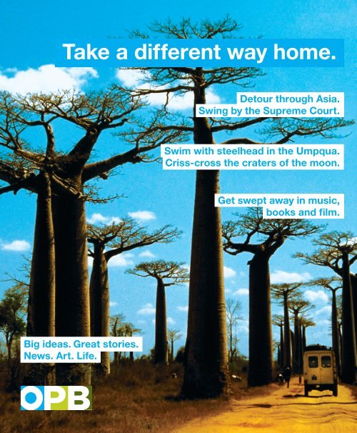
Take a different way home. Detour through Asia. Swing by the Supreme Court. Swim with steelhead in the Umpqua. Criss-cross the craters of the moon. Get swept away in music, books and film. Big ideas. Great stories. News. Art. Life.
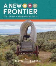
Around the State Road Reconsidered Highway 20: Bend to Burns A sense of challenge arose in Stu Garrett, a doctor, a historian and Bend resident, when he heard one too many times that the highway from Bend to Burns was “the most boring road in Oregon.” Within three years, Garrett produced a manuscript of historical, geological and ecological scholarship milepost-bymilepost from Bend to Burns. The events of Highway 20 are perhaps Oregon’s most interesting combination of geology, and Native American and pioneer culture in one stretch. Fact: U.S. Route 20 is an east-west United States highway. As the “0” in its route number implies, U.S. 20 is a coast-to-coast route. 9 Milepost History your taxpayer Dollars, torpedoed The Central Oregon Testing Facility (COTEF) is located north of the highway just out of view. In the early 1980s, during the Cold War, the U.S. government built this installation. This site was said to be connected to a Redmond facility and to the Backscatter Radar in Christmas Valley, 50 miles to the south. This $3 billion radar installation was meant to intercept Russian bombers flying over Siberia and Alaska to attack the U.S. badlands volcano This volcanic feature is probably a “rootless volcano” related to the Newberry Volcano complex. “Rootless” because it has no direct pipe to the crustal source of magma, instead likely connected to the Newberry Volcano by a shallow lava tube or tubes. It has some spectacular ancient junipers struggling for centuries on the stark lava. If you haven’t hiked here on a clear winter day, turn to page 50 for more. 13 The Great Basin The large, usually dry lake basins of Harney and Lake Counties are the northern-most extension of the Great Basin. The Great Basin is part of the Basin and Range province, which extends into Mexico. Because there is no river outlet to an ocean, all precipitation falling in the Great Basin must evaporate. In cooler wetter times, some of these basins held lakes that were more than 300 feet deep. The Great Basin is also an area of thin crust, high heat flow from the center of the earth and recent volcanic eruptions. The Basin and Range is a part of the Earth’s crust that has been expanding for the last 15 million years. It may have widened more than 200 miles. It has probably expanded more than twice its original width and is still expanding at about 1 centimeter per year. eXtended aRticLe If anything in this “Road Reconsidered” inspires you to learn more, please visit 1859magazine.com for the rest of the historical and geological milestones. If you’re interested in helping preserve Eastern Oregon history, contribute to Harney County Historical Museum at burnsmuseum.com. 22 newberry volcano This volcano to the south is a shieldshaped volcano with multiple cinder cones on its flanks. The earliest flows date to 600,000 years ago. In 1991, this area became Oregon’s fourth National Monument, protecting its fascinating geology, old growth ponderosa pines and plant communities. henry l. Davis, a sweet pulitzer Davis was the only Oregon author to win a Pulitzer Prize for litera- ture. Awarded in 1936 for his novel, Honey in the Horn, it is a story of rough characters in early Crook County. 42 20 1859 OREGON'S MAGAZINE WINTER <strong>2010</strong>