Climate Action 2009-2010

You also want an ePaper? Increase the reach of your titles
YUMPU automatically turns print PDFs into web optimized ePapers that Google loves.
TECHNOLOGY<br />
Competencies of the partners Value-added services Users<br />
Spatial technologies Observations Regions<br />
Communication Evolution scenarios Regional and local-scale territorial<br />
Ocean and coast Simulations communities<br />
<strong>Climate</strong> and weather Cost-benefit analyses Businesses<br />
Development and territorial GHG balance Citizen associations and<br />
planning adjustment Integrated Territorial <strong>Climate</strong> Plan organisation<br />
<strong>Action</strong> programme<br />
integrate the climate in their territorial management<br />
by improving accessibility and by disseminating and<br />
exchanging updated information on how to use them<br />
based on existing or developing territorial experiences.<br />
Furthermore, this hub expertise domain covers a large<br />
panel of issues thanks to the dynamic developing network.<br />
ClimSAT, a methodological charter to assess and<br />
map vulnerabilities to climate change<br />
ClimSAT’s mission is to facilitate and guide the regions<br />
in sourcing and using satellite and other geo-spatial<br />
information and related management technologies to<br />
assess the physical impact of climate change and the<br />
associated vulnerabilities in a given territory.<br />
The climate change vulnerability approach developed by<br />
ClimSAT consists of three-dimensional visual models<br />
expressing the incidence of current climatic conditions<br />
on the functioning and sustainability of local ecological<br />
environment (land, water, ecosystems, forest and<br />
protected areas, etc…), economy (agriculture, fisheries,<br />
industries, rural and urban service infrastructures,<br />
etc..) and society (living and working conditions, health,<br />
education, social and cultural services, etc…). By further<br />
integrating two extreme IPCC climate change scenarios<br />
(most optimistic and most pessimistic) in the climatic<br />
vulnerability modeling systems, future climate risks and<br />
hotspots induced by global warming will be evidenced in<br />
each regional territory and easily qualified and quantified.<br />
Different adaptive as well as mitigation options can be<br />
visualised and corresponding projects evaluated. This<br />
approach aims to ensure the full participation of local<br />
actors of the specific climate change vulnerabilities<br />
of their territory and, by using intuitive visualisation<br />
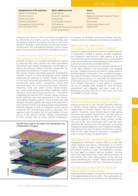
ClimSAT basic maps for the study of the metropolitan area<br />
of Montevideo in Uruguay.<br />
techniques, to facilitate consensus-building, decisionmaking,<br />
resource mobilisation and decision acceptance.<br />
MAPPING THE TERRITORIAL<br />
VULNERABILITY TO CLIMATE CHANGE<br />
Given the complexity and the numerous relevant pieces<br />
of information needed to express possible adaptation<br />
and mitigation opportunities, maps appear to be the<br />
most efficient tool to communicate results. Vulnerability<br />
maps allow analysing and developing possible options in<br />
a universal and directly accessible manner.<br />
Remote sensing is the key tool to complete the inventory<br />
of the data needed for the assessment and mapping<br />
process. Image processing can lead to a large range of<br />
multidisciplinary information, from a simple red-greenblue<br />
view of the area of interest to a representation of the<br />
state of hydrical stress of a crop field, the classification<br />
of the land cover, or the state of the soil moisture.<br />
Such reliable information is very useful to complete<br />
the set of available data needed for each territorial<br />
assessment and mapping; and even more so in<br />
developing countries that are, in most cases, the most<br />
vulnerable to climate change.<br />
PROMOTE AND DEVELOP ACCESS TO AND<br />
USE OF DOWNSCALED CLIMATIC DATA<br />
Helping territories to plan efficient planning response<br />
to climate change requires understanding the spatial<br />
organisation of climate impacts that are highly sitespecific.<br />
Therefore, future climate data of high spatial<br />
resolution are needed. Furthermore, the four types of<br />
scenarios developed by IPCC are currently the most<br />
commonly applied to simulate future climatic trends.<br />
The use of the most pessimistic A1F1 and the most<br />
optimistic B2 scenarios are thus pertinent to visualise<br />
the panel of needed adaptation and mitigation strategies.<br />
Depending on the type of impacts the territory is facing,<br />
more or less high temporal resolution is employed in<br />
order to study the physical phenomenon.<br />
GEOGRAPHICAL INFORMATION SYSTEMS<br />
Geographical Information System (GIS) is a tool that<br />
shows features and feature relationships on a chosen<br />
surface. Most of all, type of data can be georeferenced<br />
and used to construct a map. The information can then<br />
be used again to support queries, analysis, crossing<br />
with other information and, at last, editing the layers of<br />
information. This clear representation of the territory<br />
allows identifying the “hotspot” where attention should<br />
be focused according to one set of indicators or queries.<br />
SATELLITE 119<br />
© ClimSAT<br />
HELPING THE TERRITORY TO DEVELOP<br />
THEIR CAPACITY BUILDING<br />
Tackling climate change is a long-term process that has<br />
to be appropriated by local actors. The sustainability of<br />
development projects, as outlined in the Declaration de<br />
VISIT: WWW.CLIMATEACTIONPROGRAMME.ORG