Climate Action 2010-2011

Create successful ePaper yourself
Turn your PDF publications into a flip-book with our unique Google optimized e-Paper software.
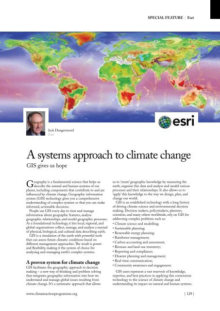
SPECIAL FEATURE | Esri<br />
Jack Dangermond<br />
Esri<br />
A systems approach to climate change<br />
GIS gives us hope<br />
Geography is a fundamental science that helps us<br />
describe the natural and human systems of our<br />
planet, including components that contribute to and are<br />
influenced by climate change. Geographic information<br />
system (GIS) technology gives you a comprehensive<br />
understanding of complex systems so that you can make<br />
informed, actionable decisions.<br />
People use GIS every day to view and manage<br />
information about geographic features, analyse<br />
geographic relationships, and model geographic processes.<br />
As a foundational technology, it lets local, regional, and<br />
global organisations collect, manage, and analyse a myriad<br />
of physical, biological, and cultural data describing earth.<br />
GIS is a simulation of the earth with powerful tools<br />
that can assess future climatic conditions based on<br />
different management approaches. The result is power<br />
and flexibility, making it the system of choice for<br />
analysing and managing earth’s complex systems.<br />
A proven system for climate change<br />
GIS facilitates the geographic approach to decision<br />
making – a new way of thinking and problem solving<br />
that integrates geographic information into how we<br />
understand and manage global issues resulting from<br />
climate change. It’s a systematic approach that allows<br />
us to ‘create’ geographic knowledge by measuring the<br />
earth, organise this data and analyse and model various<br />
processes and their relationships. It also allows us to<br />
‘apply’ this knowledge to the way we design, plan, and<br />
change our world.<br />
GIS is an established technology with a long history<br />
of driving climate science and environmental decision<br />
making. Decision makers, policymakers, planners,<br />
scientists, and many others worldwide, rely on GIS for<br />
addressing complex problems such as:<br />
• <strong>Climate</strong> science and modelling;<br />
• Sustainable planning;<br />
• Renewable energy planning;<br />
• Rainforest management;<br />
• Carbon accounting and assessment;<br />
• Biomass and land-use inventory;<br />
• Reporting and compliance;<br />
• Disaster planning and management;<br />
• Real-time communication;<br />
• Community awareness and engagement.<br />
GIS users represent a vast reservoir of knowledge,<br />
expertise, and best practices in applying this cornerstone<br />
technology to the science of climate change and<br />
understanding its impact on natural and human systems.<br />
www.climateactionprogramme.org | 129 |