Climate Action 2014-2015

Create successful ePaper yourself
Turn your PDF publications into a flip-book with our unique Google optimized e-Paper software.
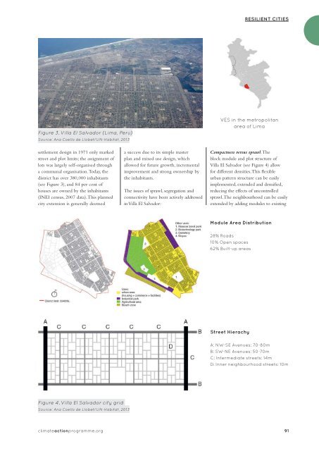
RESILIENT CITIES<br />
Figure 3. Villa El Salvador (Lima, Peru)<br />
Source: Ana Coello de Llobet/UN-Habitat, 2013<br />
VES in the metropolitan<br />
area of Lima<br />
settlement design in 1971 only marked<br />
street and plot limits; the assignment of<br />
lots was largely self-organised through<br />
a communal organisation. Today, the<br />
district has over 380,000 inhabitants<br />
(see Figure 3), and 84 per cent of<br />
houses are owned by the inhabitants<br />
(INEI census, 2007 data). This planned<br />
city extension is generally deemed<br />
a success due to its simple master<br />
plan and mixed use design, which<br />
allowed for future growth, incremental<br />
improvement and strong ownership by<br />
the inhabitants.<br />
The issues of sprawl, segregation and<br />
connectivity have been actively addressed<br />
in Villa El Salvador:<br />
Compactness versus sprawl. The<br />
block module and plot structure of<br />
Villa El Salvador (see Figure 4) allow<br />
for different densities. This flexible<br />
urban pattern structure can be easily<br />
implemented, extended and densified,<br />
reducing the effects of uncontrolled<br />
sprawl. The neighbourhood can be easily<br />
extended by adding modules to existing<br />
Module Area Distribution<br />
28% Roads<br />
10% Open spaces<br />
62% Built-up areas<br />
Street Hierachy<br />
A: NW-SE Avenues: 70-80m<br />
B: SW-NE Avenues: 50-70m<br />
C: Intermediate streets: 14m<br />
D: Inner neighbourhood streets: 10m<br />
Figure 4. Villa El Salvador city grid<br />
Source: Ana Coello de Llobet/UN-Habitat, 2013<br />
climateactionprogramme.org 91